
Montana has 8 USDA planting zones — 3a through 6b, per the 2023 USDA Plant Hardiness Zone Map. Annual minimum winter temperatures range from -40°F to 0°F across the state, spanning Montana’s growing, hardiness, and gardening zone classifications.
Zone 3a, the coldest, is found in small pockets in the northeast, while zones 3b and 4a dominate the northern and eastern parts of the state. Zones 4b and 5a cover large areas of central and western Montana, including many populous areas. Zones 5b and 6a are primarily located in the western valleys, with zone 6b, the warmest, limited to a tiny area in the extreme northwest.
Find your Montana plant zone below using the ZIP code search or the interactive Montana planting zone map. For a full lookup by town or county, see USDA hardiness zones for Montana cities, towns, and counties.
Search Montana Planting Zones by ZipCode
Planting Zones Montana Map
Select your Montana city from the selection box below. Use the top-right corner button in the map view to toggle map layers.
Planting Zones
Planting Zones
What are the 8 planting zones in Montana?
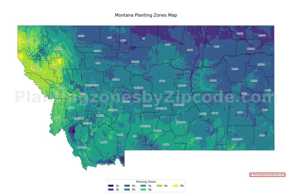
1. Zone 3a
Zone 3a, shown by the darkest purple areas on the map above, is the coldest planting zone in Montana. With average annual minimum temperatures ranging from -40°F to -35°F (-40°C to -37.2°C), it covers small pockets in the northeastern part of the state. It includes some of the most extreme northern areas of Montana.
2. Zone 3b
Shown in a slightly lighter shade of purple on our map, Zone 3b experiences average annual minimum temperatures between -35°F to -30°F (-37.2°C to -34.4°C). This zone is more prevalent in the northeastern corner of Montana, extending southward along the eastern border. Cities in this zone include Chinook, Havre, Plentywood, and Scobey.
3. Zone 4a
Zone 4a, shown in dark blue on the map above, covers a large area of northern and eastern Montana. This zone experiences average annual minimum temperatures from -30°F to -25°F (-34.4°C to -31.7°C). Cities in this zone include Glasgow, Glendive, Sidney, and Wolf Point.
4. Zone 4b
Represented by teal on our map, Zone 4b covers most of central and eastern Montana. This zone experiences average annual minimum temperatures between -25°F to -20°F (-31.7°C to -28.9°C). Cities in this zone include Great Falls, Helena, Lewistown, and Miles City.
5. Zone 5a
Zone 5a, shown in dark green on the map above, covers significant areas of western and south-central Montana. With average annual minimum temperatures ranging from -20°F to -15°F (-28.9°C to -26.1°C), this zone has many of Montana’s more populous areas like Billings, Bozeman, Butte, and Missoula.
6. Zone 5b
Zone 5b, the green areas on our map above, is primarily found in the western valleys and lower elevations of Montana. This zone experiences average annual minimum temperatures between -15°F to -10°F (-26.1°C to -23.3°C). Some cities in this zone are Hamilton, Kalispell, and parts of Missoula.
7. Zone 6a
Zone 6a, shown in a brighter green shade on the map above, is limited to the lowest elevations and warmest microclimates in western Montana. With average annual minimum temperatures from -10°F to -5°F (-23.3°C to -20.6°C), this zone is found in small pockets. Cities in this zone include some parts of Missoula.
8. Zone 6b
The warmest zone in Montana, 6b, is represented by the brightest yellow on our map above. It covers only a tiny area in the extreme northwest of the state, with average annual minimum temperatures between -5°F to 0°F (-20.6°C to -17.8°C). The town of Heron falls within this zone, making it one of the mildest areas in Montana for plant hardiness.
Planting Zones in Montana with Cities
USDA hardiness zones for Montana cities, towns, and counties. Data Source: 2023 USDA Plant Hardiness Zone Map.
| Planting Zones in Montana | Temp Range (°F) | Cities |
|---|---|---|
| 5a | -20 to -15 | Absarokee, Acton, Alder, Anaconda, Basin, Bearcreek, Belfry, Belgrade, Big Timber, Billings, Boulder, Boyd, Bozeman, Bridger, Busby, Butte, Cameron, Cardwell, Clyde Park, Colstrip, Columbia Falls, Columbus, Condon, Coram, Decker, Dell, Dillon, Divide, East Helena, Edgar, Emigrant, Ennis, Essex, Eureka, Fishtail, Fortine, Fromberg, Gallatin Gateway, Greycliff, Hall, Harrison, Helena, Helmville, Jackson, Joliet, Lake Mc Donald, Lame Deer, Laurel, Lima, Livingston, Lodge Grass, Manhattan, Mc Allister, Mc Leod, Melrose, Norris, Nye, Olney, Otter, Ovando, Park City, Philipsburg, Polaris, Polebridge, Pony, Pray, Pryor, Red Lodge, Reed Point, Roberts, Roscoe, Saint Xavier, Seeley Lake, Sheridan, Silver Star, Springdale, Stryker, Sula, Three Forks, Toston, Trego, Twin Bridges, Virginia City, West Glacier, Whitefish, Whitehall, Willow Creek, Winston, Wisdom, Wise River, Yellowtail |
| 4b | -25 to -20 | Alzada, Ashland, Augusta, Avon, Babb, Baker, Ballantine, Belt, Biddle, Big Sky, Bighorn, Birney, Black Eagle, Boyes, Broadus, Broadview, Brusett, Buffalo, Butte, Bynum, Canyon Creek, Capitol, Cascade, Choteau, Clancy, Coffee Creek, Cooke City, Crow Agency, Custer, Deer Lodge, Denton, Dupuyer, East Glacier Park, Ekalaka, Elliston, Fairfield, Floweree, Forestgrove, Forsyth, Fort Harrison, Fort Shaw, Gardiner, Garrison, Garryowen, Geraldine, Geyser, Glen, Gold Creek, Grass Range, Great Falls, Hammond, Hardin, Harlowton, Hays, Heart Butte, Helena, Highwood, Hilger, Hobson, Huntley, Hysham, Ingomar, Jefferson City, Judith Gap, Lavina, Lewistown, Lincoln, Lindsay, Lloyd, Marion, Martinsdale, Marysville, Melstone, Melville, Miles City, Moccasin, Molt, Monarch, Moore, Mosby, Musselshell, Neihart, Olive, Pendroy, Pompeys Pillar, Powderville, Power, Ramsay, Rapelje, Raynesford, Ringling, Rosebud, Roundup, Roy, Ryegate, Sand Coulee, Sand Springs, Sanders, Shawmut, Shepherd, Simms, Stanford, Stockett, Sumatra, Teigen, Townsend, Two Dot, Valier, Volborg, Warm Springs, West Yellowstone, White Sulphur Springs, Willard, Wilsall, Winifred, Winnett, Wolf Creek, Worden, Wyola, Zortman |
| 4a | -30 to -25 | Angela, Bainville, Big Sandy, Bloomfield, Box Elder, Brady, Brockton, Brockway, Browning, Butte, Carter, Chester, Circle, Cohagen, Conrad, Crane, Culbertson, Cut Bank, Dodson, Dutton, Ethridge, Fairview, Fallon, Flaxville, Fort Benton, Fort Peck, Frazer, Froid, Galata, Glasgow, Glendive, Harlem, Hathaway, Hingham, Hogeland, Inverness, Ismay, Joplin, Jordan, Kevin, Kinsey, Kremlin, Lambert, Ledger, Loma, Lothair, Malta, Nashua, Oilmont, Plevna, Poplar, Raymond, Richey, Saint Marie, Savage, Shelby, Sidney, Silver Gate, Sun River, Sunburst, Sweet Grass, Terry, Turner, Ulm, Vandalia, Vaughn, Vida, Whitlash, Wibaux, Wolf Point |
| 3b | -35 to -30 | Antelope, Chinook, Dagmar, Gildford, Glentana, Havre, Hinsdale, Homestead, Larslan, Loring, Medicine Lake, Opheim, Outlook, Peerless, Plentywood, Redstone, Reserve, Richland, Rudyard, Saco, Scobey, Westby, Whitetail, Whitewater, Zurich |
| 5b | -15 to -10 | Alberton, Arlee, Bigfork, Bonner, Clinton, Conner, Corvallis, Darby, Drummond, Florence, Grantsdale, Hamilton, Hungry Horse, Huson, Kalispell, Kila, Lolo, Martin City, Milltown, Missoula, Pinesdale, Rexford, Stevensville, Victor |
| 6a | -10 to -5 | Big Arm, Charlo, Dayton, De Borgia, Dixon, Elmo, Frenchtown, Haugan, Hot Springs, Lakeside, Libby, Lonepine, Missoula, Noxon, Pablo, Paradise, Plains, Polson, Proctor, Ravalli, Rollins, Ronan, Saint Ignatius, Saint Regis, Saltese, Somers, Superior, Thompson Falls, Trout Creek, Troy |
| 6b | -5 to 0 | Heron |
Geography influence on Montana’s planting zones?
Montana’s US plant hardiness zones are directly impacted by its geography. In the eastern plains, colder zones (3a to 4a) dominate due to exposure to Arctic air masses and lack of mountainous protection. The central region, with its mix of plains and mountains, has milder zones (4b to 5a). Western Montana, sheltered by mountain ranges, experiences the mildest climates, with zones 5b to 6b in lower elevations and valleys.