
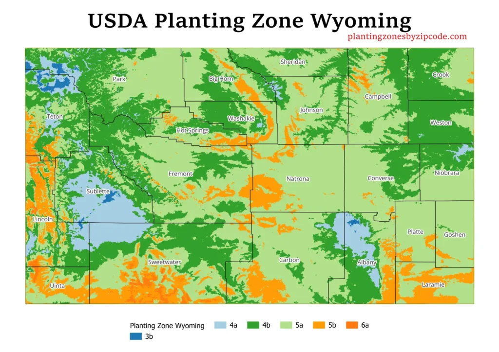
Wyoming have six USDA planting zones, ranging from 3b to 6a, based on the most recent official USDA data.
Zone 3b, the coldest, exists in the highest mountain regions and Zone 4a appears primarily in western mountain areas. Zone 4b covers most of northern and northwestern Wyoming. Zone 5a, is the most widespread, covering central and eastern parts of the state. Zone 5b is scattered throughout the state, often in transitional areas. Zone 6a, the warmest, appears in southern and western regions.
You can find your Wyoming planting zone by using our ZIP code tool or the Wyoming city planting zone map. Both tools, provided below in the post, will help you determine your exact USDA growing zone.
Search Wyoming Plating Zones by ZipCode
Planting Zones Wyoming Map
Select or type your Wyoming city name in the selection box below. Please change the mapview by selecting different layers from top-right corner button in mapview.
Planting Zones
Planting Zones
What are the 6 planting zones in Wyoming?
1. Zone 3b
Zone 3b, the coldest zone in Wyoming, is shown in dark blue color in our provided map above. With average annual minimum temperatures ranging from -35°F to -30°F (-37.2°C to -34.4°C), this zone represents the most extreme winter conditions in the state. It includes the highest elevations and most exposed areas of Wyoming’s mountain ranges.
2. Zone 4a
Represented by light blue color areas on our map, Zone 4a have average annual minimum temperatures between -30°F and -25°F (-34.4°C to -31.7°C). This zone is scattered across Wyoming, mostly in higher elevation areas and valleys. Some locations in this zone are Big Piney, Bosler, Boulder, and Moose. It’s particularly prevalent in the western part of the state, including areas around Jackson Hole and parts of the Wind River Range.
3. Zone 4b
Shown in dark green color on our map above, Zone 4b covers large area of Wyoming, especially in the north and northwest. This zone has average annual minimum temperatures from -25°F to -20°F (-31.7°C to -28.9°C). Some cities in this zone are Dubois, Jackson, and Pinedale. It includes most of the Bighorn Basin, parts of the Yellowstone region, and extends into the northeastern corner of the state.
4. Zone 5a
Zone 5a, shown in light green color on our map, is the most widespread zone in Wyoming. It covers most of the central and eastern parts of the state, with average annual minimum temperatures ranging from -20°F to -15°F (-28.9°C to -26.1°C). This zone have many of Wyoming’s major population centers such as Cody, Casper, Cheyenne, Gillette, and Sheridan. It also covers vast areas of the high plains and lower elevation mountain foothills.
5. Zone 5b
Shown by light orange colored areas on our map, Zone 5b is scattered throughout Wyoming, often in transitional areas between lower and higher elevations. This zone experiences average annual minimum temperatures from -15°F to -10°F (-26.1°C to -23.3°C). Cities in this zone are Afton, Cheyenne, Laramie (some parts), and Rock Springs. It’s particularly noticeable in the southern parts of the state and around some of the mountain ranges.
6. Zone 6a
The warmest zone in Wyoming, 6a, is shown in dark orange color on our map above. It appears in the state’s southern and western regions, with average annual minimum temperatures between -10°F and -5°F (-23.3°C to -20.6°C). It includes some of the lowest elevation areas and protected valleys in Wyoming, near the borders with Utah and Colorado.
Planting Zones in Wyoming with Cities
USDA hardiness zones for Wyoming cities, towns and counties. Data Source USDA (2023 latest Release)
| Planting Zones in Wyoming | Temp Range (°F) | Cities |
|---|---|---|
| 5b | -15 to -10 | Afton, Albin, Alpine, Bairoil, Bedford, Buford, Carpenter, Cheyenne, Etna, Fe Warren Afb, Fort Bridger, Granite Canon, Horse Creek, Laramie, Lonetree, Mc Kinnon, Mountain View, Rock Springs, Savery, Thayne, Tie Siding, Wilson |
| 4a | -30 to -25 | Big Piney, Bosler, Boulder, Cokeville, Daniel, Farson, La Barge, Laramie, Medicine Bow, Moose |
| 5a | -20 to -15 | Aladdin, Alcova, Alta, Alva, Arapahoe, Arminto, Banner, Beulah, Big Horn, Buffalo, Burlington, Burns, Byron, Casper, Centennial, Chugwater, Clearmont, Cody, Cowley, Crowheart, Deaver, Douglas, Edgerton, Elk Mountain, Emblem, Encampment, Evanston, Evansville, Fairview, Fort Laramie, Fort Washakie, Frannie, Freedom, Garrett, Gillette, Glendo, Glenrock, Green River, Guernsey, Hanna, Hartville, Hawk Springs, Hiland, Hillsdale, Hudson, Huntley, Hyattville, Jay Em, Jelm, Kaycee, Kelly, Kemmerer, Kinnear, Lagrange, Lander, Linch, Lingle, Little America, Lost Springs, Lovell, Lusk, Lyman, Lysite, Manville, Meriden, Midwest, Mills, Moran, Natrona, Parkman, Pavillion, Pine Bluffs, Point Of Rocks, Powder River, Powell, Ralston, Ranchester, Rawlins, Recluse, Reliance, Riverton, Robertson, Rock Springs, Saddlestring, Saratoga, Shawnee, Shell, Sheridan, Sinclair, Smoot, Story, Superior, Ten Sleep, Thermopolis, Torrington, Van Tassell, Veteran, Walcott, Wapiti, Wheatland, Wolf, Wright, Wyarno, Yoder |
| 4b | -25 to -20 | Arvada, Auburn, Baggs, Basin, Bondurant, Cora, Dayton, Devils Tower, Diamondville, Dixon, Dubois, Frontier, Granger, Greybull, Grover, Hulett, Jackson, Jeffrey City, Kirby, Lance Creek, Laramie, Leiter, Manderson, Meeteetse, Moorcroft, Newcastle, Opal, Osage, Otto, Pinedale, Rock River, Rozet, Saint Stephens, Shirley Basin, Shoshoni, Sundance, Teton Village, Upton, Wamsutter, Weston, Worland, Yellowstone National Park |
Best plants for Wyoming?
The 6 best plants well-adapted to Wyoming’s US Agricultural zones, each being a prominent species in its respective zone, are:
- Zone 3b: Engelmann Spruce
- Zone 4a: Rocky Mountain Juniper
- Zone 4b: Blue Spruce
- Zone 5a: Ponderosa Pine
- Zone 5b: Quaking Aspen
- Zone 6a: Gambel Oak