
Washington State has 12 USDA planting zones, ranging from 4a to 9b, based on the most recent USDA official data released in 2023. Most gardeners in western Washington, including Seattle and Olympia, fall in zones 8a-8b. Spokane and eastern Washington are in zones 6b-7a, while the Tri-Cities area (Richland, Kennewick, Pasco) sits in zone 7b. The mildest zones (9a-9b) appear along the Pacific coast, and the coldest zones (4a-5b) are found in the Cascade Mountains.
You can find your Washington planting zone by using our ZIP code tool or the Washington city planting zone map. Both tools, provided below, will help you determine your exact USDA growing zone.
Search Washington State Planting Zones by Zip Code
Planting Zones Washington State Map
Select or type your Washington city name in the selection box below. Please change the map layers from the top-right corner button in the map view.
Planting Zones
Planting Zones
What are the 12 planting zones in Washington State?
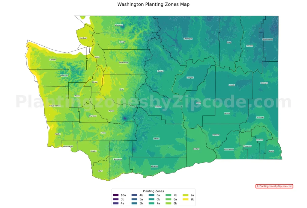
1. Zone 4a
This zone, shown in dark purple color on our map, appears in tiny, isolated patches at the highest elevations of the Cascade Mountains. With average annual minimum temperatures ranging from -30°F to -25°F (-34.4°C to -31.7°C), it represents the coldest areas in Washington. These are mostly found on the peaks of mountains such as Mount Rainier, Mount Adams, and Mount Baker.
2. Zone 4b
Zone 4b, shown in dark blue color on our map, covers slightly larger areas at very high elevations in the Cascades. Experiencing minimum temperatures between -25°F to -20°F (-31.7°C to -28.9°C), this zone is present on the upper slopes of major peaks and some high mountain passes that include parts of popular hiking and skiing areas.
3. Zone 5a
Shown in blue color on the map, Zone 5a covers broader areas of high elevation in the Cascade Range and small portions of the Olympic Mountains. With minimum temperatures from -20°F to -15°F (-28.9°C to -26.1°C), this zone covers subalpine regions. It includes areas near mountain towns and resorts.
4. Zone 5b
Zone 5b, shown in light blue color on the map, appears in larger areas across the higher elevations of the Cascades and the highest parts of the Olympic Mountains. This zone experiences minimum temperatures between -15°F to -10°F (-26.1°C to -23.3°C).
These above four zones are crucial for high-altitude ecosystems and specialized alpine plants, but they cover very small areas of Washington State compared to the more widespread warmer zones.
5. Zone 6a
Zone 6a, the teal colored areas on the map, covers a small area in the northeastern part of Washington. With average annual minimum temperatures ranging from -10°F to -5°F (-23.3°C to -20.6°C), it represents some of the coldest areas in the state. Some cities in this zone are Chewelah, Colville, and Republic.
6. Zone 6b
This zone, depicted in dark green color on our map above, extends across much of eastern Washington. With minimum temperatures from -5°F to 0°F (-20.6°C to -17.8°C), it covers a significant area of the state’s agricultural regions. Some cities in Zone 6b include Spokane, Pullman, and Winthrop.
7. Zone 7a
Zone 7a, represented by a lighter green color on the map above, is found in central Washington and along the Columbia River Gorge. With minimum temperatures ranging from 0°F to 5°F (-17.8°C to -15°C), it includes areas like the Yakima Valley and parts of the Cascade foothills. Some cities in this zone are Wenatchee, Ellensburg, and Moses Lake.
8. Zone 7b
Shown in a pale green color on our map, Zone 7b covers parts of central and south-central Washington. This zone experiences minimum temperatures between 5°F to 10°F (-15°C to -12.2°C). It includes the Tri-Cities area, with cities like Richland, Kennewick, and Pasco.
9. Zone 8a
Zone 8a, shown in a light yellow-green color on our map, is found in the western part of the state, including most of the Puget Sound region. With minimum temperatures from 10°F to 15°F (-12.2°C to -9.4°C), it covers areas like the Olympic Peninsula and parts of the Cascade foothills. Some key cities here are Olympia, Chehalis, and Bellingham.
10. Zone 8b
This zone, shown in a brighter yellow-green color on our map above, covers most of western Washington, including the Seattle metropolitan area and the coast. Experiencing minimum temperatures between 15°F to 20°F (-9.4°C to -6.7°C), it’s home to cities like Seattle, Tacoma, and Vancouver.
11. Zone 9a
Zone 9a, shown by a yellow color on the map above, is found along the Pacific coast and in some protected areas of the Puget Sound. With minimum temperatures ranging from 20°F to 25°F (-6.7°C to -3.9°C), it includes coastal cities such as Aberdeen, Ocean Shores, and parts of the San Juan Islands.
12. Zone 9b
The warmest zone in Washington, 9b, is shown in a bright yellow color on our map above and is only found in a tiny area on the southern coast. Experiencing minimum temperatures between 25°F to 30°F (-3.9°C to -1.1°C), it includes the town of Tokeland, representing the mildest winter conditions in the state.
Planting Zones in Washington State with Cities
List of USDA Hardiness zones in Washington cities, towns and counties. As per USDA official data-2023 latest release.
| Planting Zones in Washington State | Temp Range (°F) | Cities |
|---|---|---|
| 8b | 15 to 20 | Aberdeen, Adna, Allyn, Amanda Park, Amboy, Anacortes, Anderson Island, Ariel, Arlington, Auburn, Battle Ground, Beaver, Belfair, Bellevue, Bellingham, Black Diamond, Blaine, Bonney Lake, Bothell, Bow, Bremerton, Brinnon, Brush Prairie, Buckley, Bucoda, Burlington, Camano Island, Camas, Camp Murray, Carbonado, Carlsborg, Carnation, Carrolls, Castle Rock, Cathlamet, Centralia, Chimacum, Chinook, Cinebar, Clearlake, Clinton, Conway, Cosmopolis, Coupeville, Custer, Dupont, Duvall, Eatonville, Elma, Everett, Fall City, Federal Way, Ferndale, Forks, Freeland, Galvin, Gig Harbor, Graham, Grapeview, Grays River, Greenbank, Hamilton, Hansville, Heisson, Hobart, Hoodsport, Hoquiam, Humptulips, Issaquah, Kalama, Kapowsin, Kelso, Kent, Kirkland, La Center, La Conner, La Grande, Lacey, Lake Stevens, Lakebay, Lakewood, Langley, Lebam, Lilliwaup, Longbranch, Longview, Lummi Island, Lyman, Malone, Maple Valley, Marysville, Matlock, Menlo, Milton, Monroe, Montesano, Morton, Mount Vernon, Mukilteo, Naselle, Neilton, Oak Harbor, Olalla, Olga, Olympia, Onalaska, Orting, Pacific, Point Roberts, Port Angeles, Port Hadlock, Port Ludlow, Port Orchard, Port Townsend, Poulsbo, Preston, Puyallup, Quilcene, Quinault, Rainier, Ravensdale, Redmond, Renton, Ridgefield, Rochester, Rosburg, Roy, Ryderwood, Salkum, Sammamish, Satsop, Seabeck, Sedro Woolley, Sequim, Shelton, Silvana, Silver Creek, Silverdale, Silverlake, Skamokawa, Snohomish, Snoqualmie, South Prairie, Spanaway, Stanwood, Startup, Steilacoom, Sultan, Sumner, Tacoma, Taholah, Tahuya, Tenino, Union, University Place, Vader, Vancouver, Vaughn, Washougal, Wauna, Wilkeson, Woodinville, Woodland, Yacolt, Yelm |
| 9a | 20 to 25 | Bainbridge Island, Bay Center, Bellevue, Blakely Island, Bremerton, Burley, Burton, Clallam Bay, Copalis Beach, Copalis Crossing, Deer Harbor, Eastsound, Edmonds, Everett, Fox Island, Friday Harbor, Gig Harbor, Grayland, Ilwaco, Indianola, Joyce, Kenmore, Kent, Keyport, Kingston, Kirkland, La Push, Long Beach, Lopez Island, Lynnwood, Manchester, Medina, Mercer Island, Moclips, Mountlake Terrace, Nahcotta, Neah Bay, Nordland, North Bonneville, Ocean Park, Ocean Shores, Orcas, Oysterville, Pacific Beach, Port Gamble, Port Orchard, Redmond, Renton, Retsil, Rollingbay, Seahurst, Seattle, Seaview, Sekiu, Shaw Island, South Bend, South Colby, Southworth, Suquamish, Tacoma, Tracyton, Vashon, Waldron, Westport |
| 8a | 10 to 15 | Acme, Baring, Bellingham, Carson, Chehalis, Concrete, Cougar, Curtis, Dallesport, Darrington, Deming, Doty, East Olympia, Elbe, Enumclaw, Ethel, Everson, Glenoma, Gold Bar, Granite Falls, Husum, Index, Littlerock, Lynden, Maple Falls, Mccleary, Mineral, Mossyrock, Napavine, Nooksack, North Bend, North Lakewood, Oakville, Olympia, Pe Ell, Randle, Raymond, Skykomish, Stevenson, Sumas, Toledo, Toutle, Tumwater, Underwood, Winlock |
| 7a | 0 to 5 | Albion, Anatone, Appleton, Ardenvoir, Ashford, Asotin, Benge, Brewster, Bridgeport, Brownstown, Buena, Burbank, Cashmere, Chelan, Cle Elum, Colfax, College Place, Colton, Connell, Coulee Dam, Cowiche, Dayton, Dixie, Dryden, East Wenatchee, Easton, Electric City, Ellensburg, Eltopia, Endicott, Entiat, Fruitland, George, Glenwood, Goldendale, Grand Coulee, Granger, Harrah, Hay, Hooper, Kahlotus, Keller, Lacrosse, Leavenworth, Lincoln, Lind, Mabton, Malaga, Manson, Marblemount, Mattawa, Mesa, Methow, Monitor, Moses Lake, Moxee, Naches, Okanogan, Orondo, Othello, Packwood, Palisades, Paradise Inn, Parker, Pasco, Pateros, Peshastin, Pomeroy, Prescott, Quincy, Rock Island, Rockport, Ronald, Roosevelt, Roslyn, Royal City, Selah, Snoqualmie Pass, Soap Lake, South Cle Elum, Spokane, Thorp, Tieton, Toppenish, Touchet, Trout Lake, Uniontown, Vantage, Veradale, Waitsburg, Walla Walla, Wapato, Warden, Washtucna, Wellpinit, Wenatchee, White Swan, Yakima, Zillah |
| 7b | 5 to 10 | Benton City, Beverly, Bickleton, Bingen, Centerville, Chelan Falls, Clarkston, Elmer City, Grandview, Kennewick, Klickitat, Longmire, Lyle, Outlook, Pasco, Paterson, Plymouth, Prosser, Richland, Starbuck, Sunnyside, Wahkiacus, Wallula, Wenatchee, West Richland, White Salmon, Wishram |
| 9b | 25 to 30 | Tokeland |
| 6b | -5 to 0 | Addy, Airway Heights, Almira, Belmont, Carlton, Chattaroy, Cheney, Colbert, Conconully, Coulee City, Creston, Danville, Davenport, Deer Park, Edwall, Elk, Ephrata, Evans, Fairchild Air Force Base, Fairfield, Farmington, Ford, Four Lakes, Garfield, Gifford, Greenacres, Harrington, Hartline, Hunters, Inchelium, Kettle Falls, Kittitas, Lamona, Lamont, Latah, Laurier, Liberty Lake, Malden, Malott, Mansfield, Marlin, Marshall, Mead, Medical Lake, Mica, Mohler, Nespelem, Newman Lake, Nine Mile Falls, Northport, Oakesdale, Odessa, Omak, Orient, Otis Orchards, Palouse, Pullman, Reardan, Rice, Ritzville, Riverside, Rockford, Rosalia, Saint John, Spangle, Spokane, Sprague, Springdale, Stehekin, Steptoe, Stratford, Tekoa, Thornton, Tonasket, Tumtum, Twisp, Valley, Valleyford, Waterville, Waverly, Wilbur, Wilson Creek, Winthrop |
| 6a | -10 to -5 | Chewelah, Clayton, Colville, Curlew, Cusick, Ione, Loomis, Loon Lake, Malo, Mazama, Metaline, Metaline Falls, Newport, Oroville, Republic, Usk, Wauconda |
What are the geographical features that influence Washington’s planting zones?
Washington State’s 12 USDA growing zones are primarily influenced by the following geographical features:
- Cascade Mountains: This mountain range divides the state into western and eastern regions. The western side experiences milder temperatures and higher rainfall, while the eastern side is drier and experiences more temperature extremes.
- Pacific Ocean: The coastal areas benefit from the moderating effect of the Pacific Ocean, resulting in milder winters and cooler summers. This influence is particularly evident in zones 8b and 9a along the coast.
- Columbia River Basin: This large river system in eastern Washington influences local microclimates, particularly in zones 6b and 7a.
- Puget Sound: This inland body of water moderates temperatures in the surrounding areas, contributing to the prevalence of zones 8a and 8b in the region.
- Elevation: Variations in altitude across the state significantly impact local climates. Higher elevations, particularly in the Cascade and Olympic mountains, experience colder temperatures, resulting in lower zone numbers.
- Rain shadow effect: The Cascade Mountains create a rain shadow in eastern Washington, leading to drier conditions and more extreme temperature fluctuations, which influence the distribution of zones 6a through 7b.