
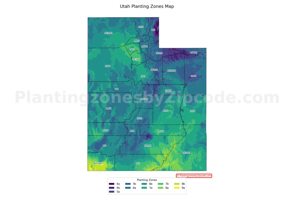
Utah has 11 USDA planting zones, ranging from zone 4a to zone 9a. Average annual minimum temperatures range from -30°F to 25°F, according to the 2023 USDA Plant Hardiness Zone Map. Northern Utah spans zones 4a through 7a due to elevation. Southern Utah spans zones 6b through 9a. Salt Lake City is in zone 7a, and St. George is in zone 8b.
Find your Utah growing zone — also called the gardening zone, plant zone, garden zone, hardiness zone, or climate zone — using our ZIP code tool or the Utah city map below. Browse every Utah city, town, and county with its USDA zone in the Utah cities, towns and counties directory.
Search Utah Planting Zones by ZipCode
Planting Zones Utah Map
Select your Utah city in the selection box below. Use the top-right corner button in the map view to toggle map layers.
Planting Zones
Planting Zones
What are the 11 planting zones in Utah?
1. Zone 4a
Zone 4a, shown in dark purple on our map, covers small pockets of the highest elevations in northern Utah. Average annual minimum temperatures range from -30°F to -25°F (-34.4°C to -31.7°C), the coldest in the state. Cities in zone 4a include Randolph in Rich County.
2. Zone 4b
Zone 4b, shown in medium purple on our map, covers higher elevations of northern Utah, including the Uinta Mountains. Average annual minimum temperatures range from -25°F to -20°F (-31.7°C to -28.9°C).
3. Zone 5a
Zone 5a, shown in light purple on our map, covers parts of Rich County and higher elevations in the Wasatch Range. Average annual minimum temperatures range from -20°F to -15°F (-28.9°C to -26.1°C). Cities in zone 5a include Garden City, Hanna, and Woodruff.
4. Zone 5b
Zone 5b, shown in dark blue on our map, covers parts of northern and central Utah. Average annual minimum temperatures range from -15°F to -10°F (-26.1°C to -23.3°C). Cities in zone 5b include Park City, Kamas, and Oakley.
5. Zone 6a
Zone 6a, shown in medium blue on our map, covers much of central Utah. Average annual minimum temperatures range from -10°F to -5°F (-23.3°C to -20.6°C). Cities in zone 6a include Logan, Nephi, Heber City, and Price.
6. Zone 6b
Zone 6b, shown in light blue on our map, covers large areas of central and northern Utah. Average annual minimum temperatures range from -5°F to 0°F (-20.6°C to -17.8°C). Cities in zone 6b include Cedar City, Eagle Mountain, Payson, and Deweyville.
7. Zone 7a
Zone 7a, shown in dark green on our map, covers lower elevations of northern Utah and parts of central Utah. Average annual minimum temperatures range from 0°F to 5°F (-17.8°C to -15°C). Cities in zone 7a include Salt Lake City, Lehi, Ogden, Provo, Orem, and Bountiful.
8. Zone 7b
Zone 7b, shown in medium green on our map, covers lower elevations of northern Utah and some southern areas. Average annual minimum temperatures range from 5°F to 10°F (-15°C to -12.2°C). Cities in zone 7b include West Jordan, Sandy, Farmington, Kaysville, and Syracuse.
9. Zone 8a
Zone 8a, shown in light green on our map, covers southwestern Utah, including Washington County. Average annual minimum temperatures range from 10°F to 15°F (-12.2°C to -9.4°C). Cities in zone 8a include Dammeron Valley, Gunlock, La Verkin, and Santa Clara.
10. Zone 8b
Zone 8b covers the warmest parts of southwestern Utah. Average annual minimum temperatures range from 15°F to 20°F (-9.4°C to -6.7°C). Cities in zone 8b include Saint George, Hurricane, Ivins, Washington, and Toquerville.
11. Zone 9a
Zone 9a, shown in bright yellow on our map, is the warmest zone in Utah and covers the lowest elevations of southwestern Utah in Washington County. Average annual minimum temperatures range from 20°F to 25°F (-6.7°C to -3.9°C). This zone includes areas near the Beaver Dam Wash National Conservation Area.
Utah Planting Zones by Region
What planting zone is northern Utah?
Northern Utah falls in USDA zones 4a through 7a, spanning a 35°F range in minimum temperatures due to elevation differences. Cities include Logan, Ogden, Park City, and Randolph.
What planting zone is central Utah?
Central Utah falls in USDA zones 5b through 7a, with average annual minimum temperatures from -15°F to 5°F. Cities include Provo, Nephi, Richfield, and Price.
What planting zone is southern Utah?
Southern Utah falls in USDA zones 6b through 9a, with average annual minimum temperatures from -5°F to 25°F. Cities include St. George, Cedar City, Hurricane, and Kanab.
What planting zone is Salt Lake City?
Salt Lake City is primarily in USDA zone 7a, with average annual minimum temperatures from 0°F to 5°F. Higher-elevation neighborhoods span zones 6a, 6b, and 7b across the valley and foothills.
What planting zone is St. George?
Saint George is in USDA zone 8b, with average annual minimum temperatures from 15°F to 20°F. Saint George sits in Washington County in southwestern Utah.
Planting Zones in Utah with Cities
Find the USDA hardiness zone for every Utah city, town, and county in the table below. Data Source: 2023 USDA Plant Hardiness Zone Map.
| Planting Zones in Utah | Temp Range (°F) | Cities |
|---|---|---|
| 5b | -15 to -10 | Altamont, Antimony, Beryl, Bluebell, Chester, Circleville, Coalville, Dutch John, Fairview, Fort Duchesne, Fountain Green, Greenwich, Jensen, Kamas, Kingston, Laketown, Lapoint, Manila, Moroni, Mount Pleasant, Myton, Newcastle, Oakley, Park City, Peoa, Randlett, Roosevelt, Scipio, Trenton, Tridell, Vernal, Wales |
| 6a | -10 to -5 | Alton, Altonah, American Fork, Annabella, Aurora, Axtell, Beaver, Bicknell, Bonanza, Brian Head, Bryce, Cache Junction, Cannonville, Castle Dale, Cedar Valley, Centerfield, Clarkston, Clawson, Cleveland, Collinston, Cornish, Croydon, Delta, Duchesne, Duck Creek Village, Echo, Eden, Elmo, Elsinore, Ephraim, Fielding, Fillmore, Fruitland, Garrison, Glenwood, Greenville, Gunnison, Hatch, Heber City, Helper, Henefer, Hinckley, Holden, Howell, Huntington, Huntsville, Hyde Park, Hyrum, Joseph, Junction, Koosharem, Leamington, Levan, Lewiston, Loa, Logan, Lyman, Lynndyl, Manti, Mantua, Marysvale, Mayfield, Mendon, Midway, Milford, Millville, Minersville, Monroe, Morgan, Mountain Home, Neola, Nephi, Newton, Orangeville, Panguitch, Paradise, Paragonah, Park City, Park Valley, Parowan, Plymouth, Portage, Price, Providence, Redmond, Richfield, Richmond, Rush Valley, Salina, Salt Lake City, Sevier, Sigurd, Smithfield, Snowville, Spanish Fork, Spring City, Sterling, Tabiona, Talmage, Teasdale, Tropic, Vernal, Wallsburg, Wellington, Wellsville, Whiterocks |
| 7a | 0 to 5 | Alpine, Bingham Canyon, Blanding, Bluff, Boulder, Bountiful, Clearfield, Draper, Enterprise, Escalante, Grantsville, Hanksville, Herriman, Hildale, Hill Afb, Hooper, Kanab, La Sal, Layton, Lehi, Lindon, Mapleton, Moab, Modena, Montezuma Creek, Mount Carmel, New Harmony, Ogden, Orem, Pleasant Grove, Provo, Riverton, Roy, Salem, Salt Lake City, Saratoga Springs, South Jordan, Tooele, Torrey, Willard |
| 6b | -5 to 0 | Bear River City, Bountiful, Brigham City, Cedar City, Centerville, Central, Cisco, Corinne, Deweyville, Dugway, Eagle Mountain, East Carbon, Elberta, Emery, Eureka, Fayette, Ferron, Garland, Glendale, Goshen, Green River, Grouse Creek, Henrieville, Honeyville, Ibapah, Kanarraville, Kanosh, Kenilworth, Meadow, Mona, Monticello, Oak City, Ogden, Orderville, Payson, Pine Valley, Provo, Riverside, Salt Lake City, Sandy, Santaquin, Springdale, Springville, Stockton, Summit, Sunnyside, Thompson, Tremonton, Vernon, Virgin, Wendover |
| 7b | 5 to 10 | Farmington, Kaysville, Magna, Mexican Hat, Midvale, North Salt Lake, Salt Lake City, Sandy, Syracuse, Veyo, West Jordan, Woods Cross |
| 5a | -20 to -15 | Garden City, Hanna, Woodruff |
| 4a | -30 to -25 | Randolph |
| 8a | 10 to 15 | Dammeron Valley, Gunlock, La Verkin, Lake Powell, Monument Valley, Rockville, Santa Clara |
| 8b | 15 to 20 | Hurricane, Ivins, Leeds, Saint George, Toquerville, Washington |
5 Best Plants for Utah Planting Zones
Utah planting zones range from 4a to 9a. Five plants suited to these zones include:
- Zone 4a: Hummingbird Fuchsia (Fuchsia magellanica) – Hardy and attracts pollinators.
- Zone 5b: Bee Balm (Monarda didyma) – Known for its vibrant flowers and pollinator attraction.
- Zone 6a: Daylily (Hemerocallis spp.) – Resilient and blooms profusely in summer.
- Zone 7b: Blanket Flower (Gaillardia spp.) – Drought-tolerant with bright, long-lasting blooms.
- Zone 9a: Lavender (Lavandula spp.) – Thrives in hot, dry conditions and is highly aromatic.