
South Dakota has four planting zones, ranging from 4a to 5b, according to the USDA’s latest 2023 plant hardiness zone map.
Zone 4a, the coldest, is found in the northeastern corner of South Dakota. Zone 4b covers most of the northern and central regions, including the Black Hills area. Zone 5a includes large areas of central and southern South Dakota, while zone 5b, the warmest, appears in scattered areas in the southern and south-western part of the state.
You can find your South Dakota planting zone by using our ZIP code tool or the South Dakota city planting zone map. Both tools, provided below in the post, will help you determine your exact USDA growing zone.
Search South Dakota Planting Zones by ZipCode
Planting Zones South Dakota Map
Please select your South Dakota city from the selection box below. Change mapview by selecting layers from top-right corner button in mapview.
Planting Zones
Planting Zones
Planting zones in South Dakota
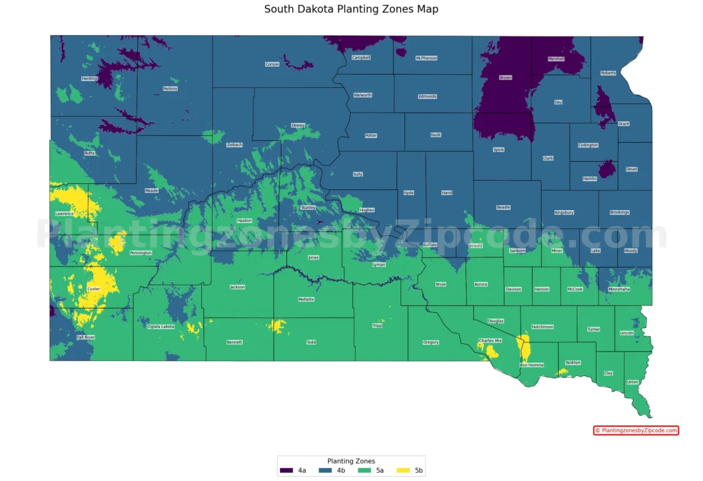
1. Zone 4a
Zone 4a, shown in deep purple color on our map above, is the coldest planting zone in South Dakota. With average annual minimum temperatures ranging from -30°F to -25°F (-34.4°C to -31.7°C), this zone is concentrated in the northeastern corner of the state. It covers a relatively small area, including cities such as Aberdeen, Groton, and Britton. This harsh climate zone requires plants that are extremely cold-hardy to thrive.
2. Zone 4b
Shown in dark blue color on our map above, Zone 4b covers large area of northern and central South Dakota. This zone has average annual minimum temperatures between -25°F and -20°F (-31.7°C to -28.9°C). It extends from the northern border southward, covering much of the eastern half of the state. Some cities in this zone are Watertown, Pierre, and Mobridge. The Black Hills region in the western part of the state also falls within this zone, creating microclimates due to its elevation.
3. Zone 5a
Zone 5a, the lighter green colored areas on the map, covers a large area of South Dakota, particularly in the central and southern regions. With average annual minimum temperatures from -20°F to -15°F (-28.9°C to -26.1°C), this zone offers a slightly milder climate than 4b. It includes much of the Missouri River valley and extends eastward to the Minnesota border. Cities in this zone are Sioux Falls, Rapid City (some parts), and Yankton. The varied terrain in this zone, from river valleys to prairies, provides diverse growing conditions.
4. Zone 5b
The warmest planting zone in South Dakota, 5b, is shown in yellow color on our map and is found in scattered areas throughout the southern part of the state. This zone has average annual minimum temperatures between -15°F and -10°F (-26.1°C to -23.3°C). Cities like Spearfish and parts of Rapid City fall into this zone. These slightly warmer areas allow for a bit more flexibility in plant choices compared to the colder zones.
Planting Zones in South Dakota with Cities
USDA hardiness zones for South Dakota Cities, Towns and Counties. As per USDA (2023) latest release:
| Planting Zones in South Dakota | Temp Range (°F) | Cities |
|---|---|---|
| 5a | -20 to -15 | Alcester, Alexandria, Allen, Armour, Avon, Baltic, Batesland, Belvidere, Beresford, Black Hawk, Bonesteel, Box Elder, Brandon, Bridgewater, Buffalo Gap, Burbank, Burke, Canistota, Canova, Canton, Caputa, Centerville, Chamberlain, Chancellor, Colome, Corsica, Crooks, Custer, Dallas, Dante, Davis, Deadwood, Delmont, Dimock, Draper, Elk Point, Emery, Ethan, Fairburn, Fairfax, Fairview, Fedora, Freeman, Fulton, Garretson, Gayville, Geddes, Gregory, Hamill, Harrisburg, Harrison, Hartford, Hermosa, Herrick, Hot Springs, Hudson, Hurley, Ideal, Interior, Irene, Jefferson, Kadoka, Kaylor, Kennebec, Keystone, Kimball, Kyle, Lake Andes, Lane, Lead, Lennox, Lesterville, Letcher, Long Valley, Lyons, Manderson, Marion, Martin, Marty, Menno, Mission, Mission Hill, Mitchell, Monroe, Montrose, Mount Vernon, Murdo, Nemo, New Holland, New Underwood, Norris, North Sioux City, Oacoma, Oelrichs, Oglala, Okaton, Okreek, Olivet, Oral, Owanka, Parker, Parkston, Parmelee, Philip, Piedmont, Pine Ridge, Plankinton, Platte, Porcupine, Presho, Pukwana, Quinn, Rapid City, Reliance, Renner, Rosebud, Saint Charles, Saint Francis, Salem, Scenic, Scotland, Sioux Falls, Smithwick, Spencer, Springfield, Stickney, Sturgis, Tabor, Tea, Tripp, Tuthill, Tyndall, Utica, Valley Springs, Vermillion, Viborg, Vivian, Volin, Wagner, Wakonda, Wall, Wanblee, Wessington Springs, White Lake, White River, Whitewood, Winner, Witten, Wood, Woonsocket, Worthing, Wounded Knee, Yankton |
| 4b | -25 to -20 | Agar, Akaska, Alpena, Andover, Arlington, Artesian, Ashton, Astoria, Aurora, Badger, Belle Fourche, Big Stone City, Bison, Blunt, Bowdle, Bradley, Brandt, Bristol, Brookings, Bruce, Bryant, Buffalo, Bullhead, Camp Crook, Carpenter, Carthage, Cavour, Cherry Creek, Chester, Claire City, Clark, Clear Lake, Colman, Colton, Corona, Cresbard, De Smet, Dell Rapids, Doland, Dupree, Eagle Butte, Eden, Edgemont, Egan, Elkton, Enning, Erwin, Estelline, Eureka, Faith, Faulkton, Flandreau, Florence, Fort Pierre, Fort Thompson, Frankfort, Frederick, Gann Valley, Garden City, Gary, Gettysburg, Glencross, Glenham, Goodwin, Grenville, Harrold, Hayes, Hayti, Hazel, Henry, Herreid, Highmore, Hill City, Hitchcock, Holabird, Hosmer, Hoven, Howard, Howes, Humboldt, Huron, Ipswich, Iroquois, Isabel, Java, Keldron, Kranzburg, Labolt, Lake Norden, Lake Preston, Lantry, Lebanon, Lemmon, Leola, Lodgepole, Longlake, Lower Brule, Ludlow, Madison, Mansfield, Marvin, Mc Intosh, Mc Laughlin, Meadow, Midland, Milbank, Milesville, Miller, Mobridge, Morristown, Mound City, Mud Butte, New Effington, Newell, Nisland, Nunda, Oldham, Onaka, Onida, Orient, Ortley, Peever, Pierpont, Pierre, Prairie City, Ralph, Ramona, Raymond, Redfield, Redig, Ree Heights, Reva, Revillo, Ridgeview, Rockham, Roscoe, Rosholt, Roslyn, Rutland, Saint Lawrence, Selby, Seneca, Sinai, Sisseton, South Shore, Stephan, Stockholm, Strandburg, Timber Lake, Tolstoy, Toronto, Trail City, Trent, Tulare, Turton, Twin Brooks, Union Center, Vale, Veblen, Vienna, Virgil, Volga, Wakpala, Walker, Wallace, Wasta, Watauga, Watertown, Waubay, Webster, Wentworth, Wessington, Westport, White, White Owl, Whitehorse, Willow Lake, Wilmot, Winfred, Wolsey, Yale |
| 4a | -30 to -25 | Aberdeen, Amherst, Barnard, Bath, Brentford, Britton, Castlewood, Claremont, Columbia, Conde, Ferney, Groton, Hecla, Houghton, Lake City, Langford, Little Eagle, Mellette, Northville, Pollock, Stratford, Summit, Warner |
| 5b | -15 to -10 | Ellsworth Afb, Pickstown, Pringle, Rapid City, Saint Onge, Spearfish |
South Dakota’s geography and planting zones?
South Dakota’s USDA growing zones are shaped by its geography in several key ways:
- Latitude: Northern regions (zones 4a and 4b) are colder due to higher latitude.
- Elevation: Black Hills area creates microclimates, influencing zones 4b and 5a.
- Continental position: Lack of large water bodies leads to temperature extremes.
- River valleys: Missouri River valley moderates climate, contributing to zone 5a.
- Topography: Varied terrain creates local climate variations within zones.