
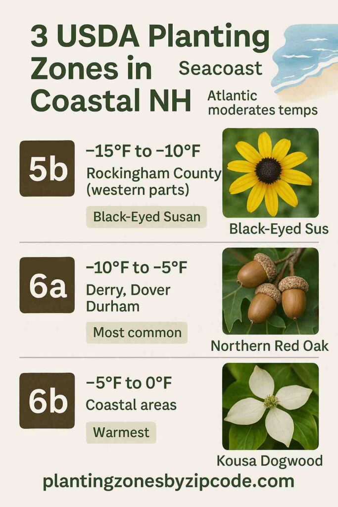
New Hampshire’s coast from Portsmouth to Londonderry has three different USDA Planting Zones 5b, 6a, and 6b, as declared by USDA update in 2023. Winter temperatures here range from -15°F to 0°F (-26.1°C to -17.8°C).
The coldest zone here is USDA zone 5b which covers parts of Rockingham County. The warmest zone is USDA zone 6b here which includes Hampton and coastal areas. Most towns like Derry, Dover, Durham, and Portsmouth are in the USDA zone 6a with winter lows of -10°F to -5°F.
Some areas here span multiple USDA zones like Hampton (6a-6b) and Rockingham County (5b-6a-6b). Smaller towns like Epping, Londonderry, Newmarket, and Raymond are all in USDA zone 6a.
USDA Growing Zones Map for New Hampshire’s Seacoast Cities
Select or type your New Hampshire coastal location in selection box below, to find its USDA Planting zone information with map.
Select a location
USDA Planting Zone
This zone’s data comes from the United States Department of Agriculture (USDA), with the most recent zone updates released in 2023
Planting Zones
Planting Zones
USDA Planting Zones Table for New Hampshire’s Coastal Cities
The table below lists all the New Hampsire coastal cities like Derry, Durham, Londonderry, Portsmouth and Raymond along with their USDA Hardniess zones.
| Location | USDA Hardiness Zone |
|---|
No items found matching your search
Try a different search term or clear the search field.
New Hampshire Seacoast USDA Planting Zones
New Hampshire’s Seacoast spans ten key locations Derry, Dover, Durham, Epping, Hampton, Londonderry, Newmarket, Portsmouth, Raymond, and Rockingham County, across three USDA Hardiness Zones (5b, 6a, and 6b).
Derry
Derry falls completely within Zone 6a (-10°F to -5°F / -23.3°C to -20.6°C). Its location away from the coast at medium height means cold air pools here during winter. This inland position creates the typical zone 6a conditions found throughout central Rockingham County.
Dover
Dover is located entirely in Zone 6a (-10°F to -5°F / -23.3°C to -20.6°C). The nearby Cocheco River and some ocean influence help keep winter lows from getting too harsh. Water bodies moderate temperature extremes better than areas without nearby water sources.
Durham
Durham sits fully in Zone 6a (-10°F to -5°F / -23.3°C to -20.6°C). Great Bay surrounds this town, creating a unique water-influenced climate that softens winter cold spells. This bay environment prevents temperatures from dropping as low as they would in purely land-locked areas.
Epping
Epping rests completely in USDA Zone 6a (-10°F to -5°F / -23.3°C to -20.6°C). The Lamprey River valley location allows chilly air to gather during calm winter nights. Even so, enough ocean warmth reaches this area to keep it out of the colder 5b zone category.
Hampton
Hampton stretches across USDA Zones 6a and 6b (-10°F to 0°F / -23.3°C to -17.8°C). Being right on the Atlantic coast at sea level creates the mildest winter conditions in the region. Ocean water stays warmer than land in winter, which reduces how cold this coastal town gets.
Londonderry
Londonderry sits entirely in USDA Zone 6a (-10°F to -5°F / -23.3°C to -20.6°C). Higher ground west of Manchester limits how much coastal warmth reaches this town. Still, enough maritime influence arrives to prevent this area from dropping into zone 5b temperatures.
Newmarket
Newmarket lies in Zone 6a (-10°F to -5°F / -23.3°C to -20.6°C). The Lamprey River plus nearby salt marshes help carry ocean warmth further inland than usual. These water features work together to keep minimum temperatures above what zone 5b would experience.
Portsmouth
Portsmouth is positioned entirely in Zone 6a (-10°F to -5°F / -23.3°C to -20.6°C). This harbor town gets strong protection from bitter cold due to the Atlantic’s heat storage capacity. Varying elevations across the city prevent uniform zone 6b warmth, keeping most areas in zone 6a.
Raymond
Raymond is placed completely in Zone 6a (-10°F to -5°F / -23.3°C to -20.6°C). Despite being further inland, low terrain near the Exeter River allows warmer coastal air to flow in. This geographic setup helps maintain zone 6a conditions instead of cooler zone 5b temperatures.
Rockingham County
Rockingham County covers USDA Zones 5b, 6a, and 6b (-15°F to 0°F / -26.1°C to -17.8°C). This large county includes everything from warm coastal flats (6b) to moderate river valleys (6a) to cooler western hills (5b). The Atlantic Ocean’s warming effect weakens as you move inland and uphill, creating this complete range of planting zones.