
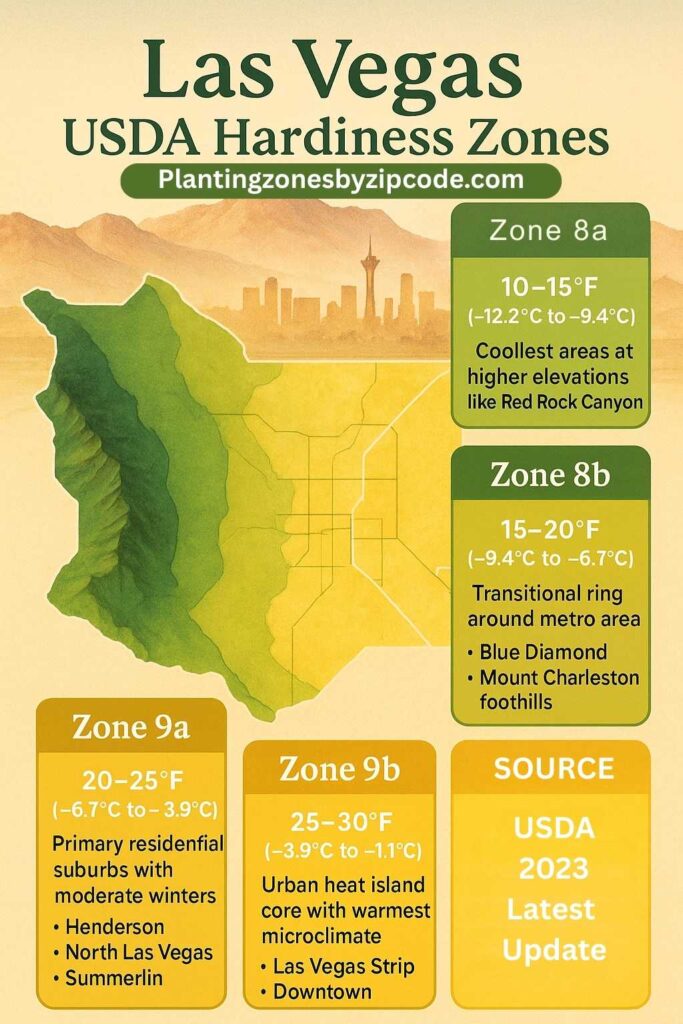
Las Vegas, Nevada falls under USDA plant hardiness zones 8a, 8b, 9a, and 9b, based on the 2023 USDA Plant Hardiness Zone Map, which uses 30-year climate data. The 4 USDA plant hardiness zones in Las Vegas, Nevada are listed below.
- Zone 8a: Zone 8a covers peripheral areas like Red Rock Canyon. Zone 8a has winter lows of 10-15°F (-12.2°C to -9.4°C).
- Zone 8b: Zone 8b has winter lows of 15-20°F (-9.4°C to -6.7°C) and encircles the metro area, covering Blue Diamond to Mount Charleston, including Summerlin.
- Zone 9a: Zone 9a spans suburbs such as North Las Vegas, Centennial Hills, and Spring Valley.
- Zone 9b: Zone 9b includes the urban core, like the Strip and downtown. Zone 9b has winter lows of 25-30°F (-3.9°C to -1.1°C).
Use our three tools given below to determine your Las Vegas, Nevada, USDA Planting zone, through zip code, by address search, or by Planting zone table.
Las Vegas Planting zones by Zipcode
Enter 5 digit Las Vegas Zipcode to find its USDA Planting Zone.
Las Vegas zones map
Please select or type your Las Vegas location name in the selection box below. to find its USDA Growing Zone.
City Name
Las Vegas Area Planting Zone
Planting Zones
Planting Zones
Las Vegas Planting zones Table
Following table lists all Las Vegas locations with their corresponding USDA Hardiness Zone. Please select or type your Las Vegas location name in the search box below.
| Las Vegas Location | Planting Zone |
|---|---|
| Loading Las Vegas zones data… | |
No items found matching your search
Try a different search term or clear the search field.
What are the planting zones in Las Vegas, Nevada?
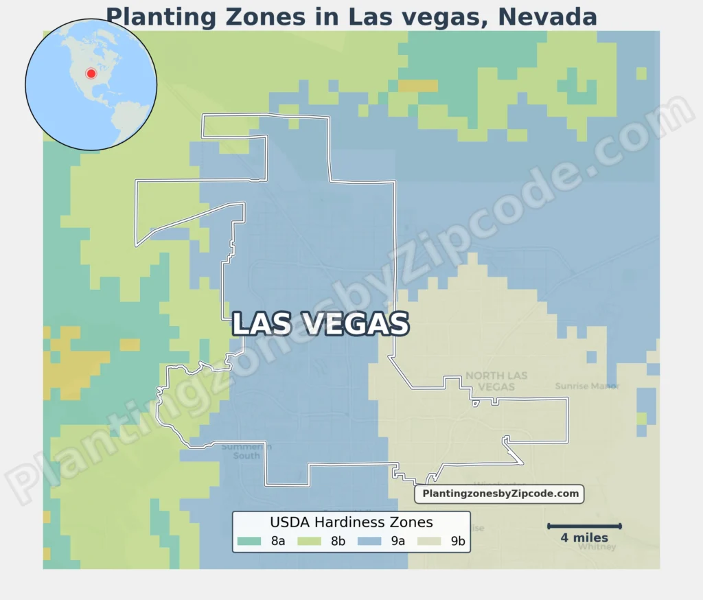
The 4 USDA plant hardiness zones in Las Vegas, Nevada are Zone 8a, Zone 8b, Zone 9a, and Zone 9b. Zone 8a occurs in peripheral areas like Red Rock Canyon, with winter lows of 10–15°F. Zone 8b encircles the metro area, spanning Blue Diamond to Mount Charleston. Zone 9a covers suburbs like Henderson and North Las Vegas, while Zone 9b includes the urban core—the Strip and neighborhoods such as Summerlin and Spring Valley.
1. Zone 8a
This zone, shown by the darkest green color areas on our map, is found in small areas around the outskirts of Las Vegas. With average annual minimum temperatures ranging from 10°F to 15°F (-12.2°C to -9.4°C), it represents the coolest areas in the region. It includes some of the higher elevation areas surrounding the city as can be seen in map.
2. Zone 8b
Zone 8b, shown in a lighter green color on our map above, forms a ring around the Las Vegas metropolitan area. It has average annual minimum temperatures between 15°F to 20°F (-9.4°C to -6.7°C). This zone includes areas like zip code 89124, which covers parts of the city’s outskirts, including the community of Sunrise Manor.
It also includes zip codes 89138, which includes the master-planned community of Summerlin West, 89161, covering parts of the city of North Las Vegas, and 89166, representing the growing area of Centennial Hills. These zip codes represent transitional areas between the cooler surroundings and the warmer urban core.
3. Zone 9a
Shown in a yellow-green color on our map, Zone 9a covers a large area of the Las Vegas metropolitan. This zone experiences average annual minimum temperatures from 20°F to 25°F (-6.7°C to -3.9°C). It includes many residential and suburban areas of Las Vegas, such as zip code 89128, which covers parts of Summerlin.
The zone also covers zip codes 89129 and 89130 in the northwest part of the city. Notable areas in this zone are Spring Valley (89146), parts of Henderson (89014, 89074), and the master-planned community of Summerlin, which spans multiple zip codes including 89134, 89135, and 89138.
4. Zone 9b
The warmest zone in Las Vegas, 9b, is represented by the yellow areas on our map above and covers the central part of the city. With average annual minimum temperatures ranging from 25°F to 30°F (-3.9°C to -1.1°C), this zone covers the urban core and some surrounding areas.
Key zip codes in this zone include 89101, which covers downtown Las Vegas, 89102 in the central west area, 89104 in the east, and 89106 in the north-central part of the city. The famous Las Vegas Strip is primarily located in zip code 89109, which is the main zip code for the area known as “The Strip.”
4 best plants for Las Vegas?
These plants are well-suited for their respective USDA Planting zones in Nevada, Las Vegas.
- Zone 8a: Lavandula angustifolia (English Lavender) – Thrives in cooler desert climates with well-drained soil.
- Zone 8b: Rosmarinus officinalis (Rosemary) – Prefers sunny locations and tolerates drought.
- Zone 9a: Citrus sinensis (Sweet Orange) – Suitable for warmer areas with protection from frost.
- Zone 9b: Phoenix dactylifera (Date Palm) – Ideal for hot, arid environments with ample sunlight.