
Kansas City, Missouri contains three distinct USDA planting zones (6a, 6b, 7a) according to the 2023 USDA Plant Hardiness Zone data. Zone 6b covers 68% of the city, while zone 6a occurs in northeastern areas like Liberty and Gladstone, and zone 7a occupies isolated patches in downtown and southern suburbs.
The microclimate gradient creates 5-8°F temperature differences, with cooler zones northeast of the Missouri River and warmer pockets in paved central/southern regions.
You can pinpoint your Kansas city (Missouri) USDA zone using our three tools given below, Zipcode to planting zone tool, Easy location based interactive map or by using planting zone table.
Kansas city Planting Zones by ZipCode
Kansas City Planting Zones Map
Select or type your Kansas city location in the selection box below, to know its USDA Planting Zone.
City Name
Kansas City Area Planting Zone
Planting Zones
Planting Zones
Kansas city Planting Zones Table
| Kansas City Location | Planting Zone |
|---|---|
| Loading Kansas City zones data… | |
No items found matching your search
Try a different search term or clear the search field.
Planting zones in Kansas City, Missouri
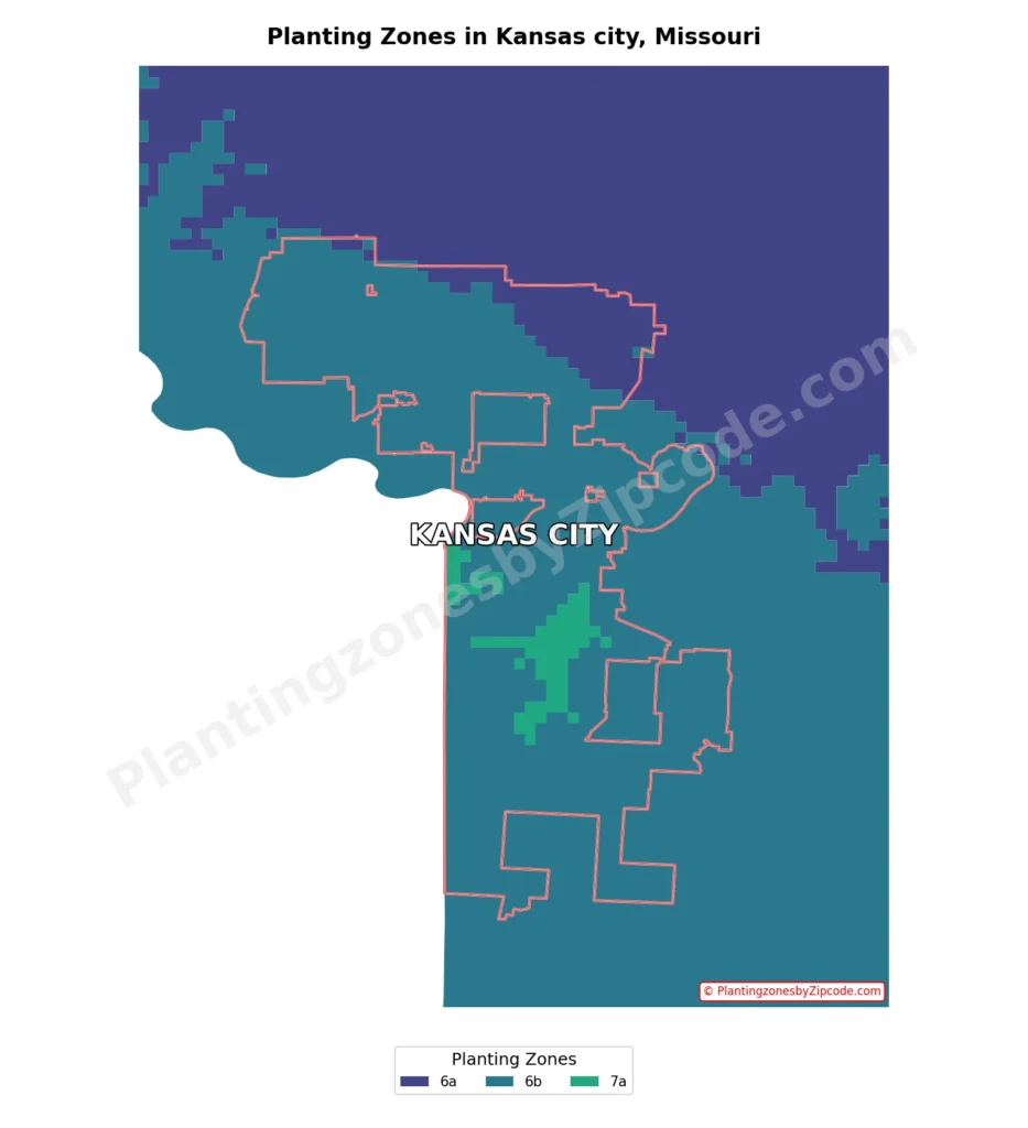
1. Zone 6a
This zone, shown in dark purple color on our map, covers a small area of the northeastern part of Kansas City. With average annual minimum temperatures ranging from -10°F to -5°F (-23.3°C to -20.6°C), it represents the coldest areas within the city limits. Some zip codes in this zone are 64156, 64157, 64165, 64166, and 64167.
2. Zone 6b
Zone 6b, blue colored areas on our map above, is the most prevalent planting zone in Kansas City. It covers the majority of the city’s area, including central, western, and southern regions. This zone experiences average annual minimum temperatures between -5°F to 0°F (-20.6°C to -17.8°C). Some zip codes in this zone include 64105, 64106, 64108, 64110, 64111, 64112, 64114, 64116, 64118, 64120, 64131, 64134, 64138, 64145, 64151, 64154, and many others throughout the city.
3. Zone 7a
The warmest planting zone in Kansas City, 7a, is shown by the light green areas on our map. It appears in scattered pockets, primarily in the southern and central parts of the city. This zone has average annual minimum temperatures ranging from 0°F to 5°F (-17.8°C to -15°C). Some zip codes falling within Zone 7a are 64101, 64102, 64108, 64129, 64130, 64141, 64179, and 64999.
The distribution of these planting zones reflects Kansas City’s varied microclimates, influenced by factors such as urban heat islands, elevation changes, topography and proximity to some water bodies. The predominance of Zone 6b across much of the city provides a consistent growing environment for a wide range of plants, while the pockets of Zones 6a and 7a offer opportunities for slightly different plant selections in those specific areas.