
Idaho contains 9 USDA planting zones, from zone 3b in the eastern high-elevation highlands to zone 7b along the westernmost Snake River Valley. The 2023 USDA Plant Hardiness Zone Map confirms these 9 zones based on average annual minimum winter temperatures.
Idaho’s planting zones — also called growing zones or hardiness zones — range from the eastern highlands to the western Snake River Valley. Eastern Idaho contains zones 3b through 5a, the coldest. Central and eastern Idaho contain zones 5b and 6a. Northern and southwestern Idaho contain zones 6b and 7a, including the Treasure Valley. The Snake River Valley in the west contains zone 7b, the warmest.
What planting zone is Idaho? Idaho contains USDA hardiness zones 3b through 7b — nine zones spanning -35°F to +10°F average winter lows. Eastern Idaho contains zones 3b, 4a, and 4b (Island Park, Monteview, Terreton). Eastern and central Idaho contain zones 5a (Arco, McCall) and 5b (Idaho Falls, Blackfoot, Salmon). Northern Idaho contains zone 6a (Sandpoint, Bonners Ferry, Pocatello) and zone 6b (Moscow, Twin Falls, Mountain Home). The Treasure Valley contains zone 7a, including Boise, Meridian, Caldwell, and Nampa. Lewiston in the Snake River Valley contains zone 7b, the warmest.
Find your Idaho planting zone below using either our ZIP code tool or our Idaho city based planting zone map. Both options will show you your exact USDA growing zone.
Search Idaho Plating Zones by ZipCode
Planting Zones Idaho Map
Select your Idaho city from selection box below. Click the top right corner button in mapview to switch map layers.
Planting Zones
Planting Zones
What are the 9 planting zones in Idaho?
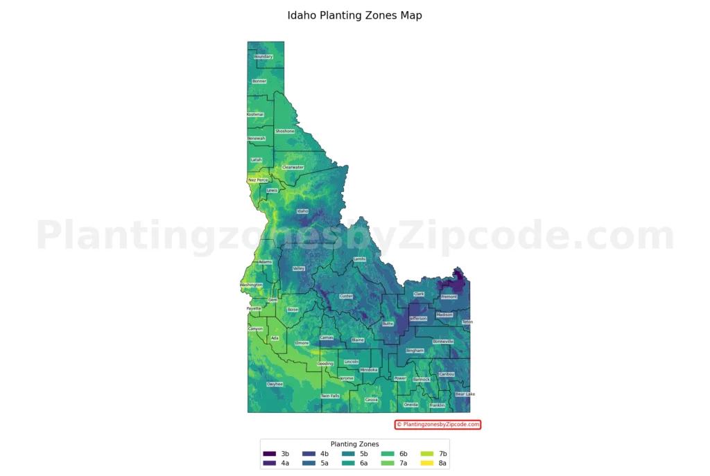
1. Zone 3b
This zone, shown in the darkest purple shade on the map above, is the coldest in Idaho with average annual minimum temperatures ranging from -35°F to -30°F (-37.2°C to -34.4°C). It covers very small area in the eastern part of the state, at high elevations.
2. Zone 4a
Represented by a slightly lighter shade of purple color on our map above, Zone 4a experiences average annual minimum temperatures between -30°F and -25°F (-34.4°C to -31.7°C). This zone is also limited in area, appearing in the eastern part of Idaho. The cities of Island Park and Macks Inn are located within this zone, known for their proximity to Yellowstone National Park.
3. Zone 4b
Shown in a medium purple color in our map, Zone 4b has average annual minimum temperatures from -25°F to -20°F (-31.7°C to -28.9°C). This zone covers a slightly larger area than 4a, still in the eastern part of the state. The cities of Monteview and Terreton are found in this zone, representing some of the coldest inhabited areas in Idaho.
4. Zone 5a
Shown in a blue color shade in the map above, Zone 5a experiences average annual minimum temperatures between -20°F and -15°F (-28.9°C to -26.1°C). This zone covers a large area of eastern and central Idaho, including higher elevation areas. Some of the cities in this zone are Arco, Ashton, and McCall, representing a mix of agricultural and suburb areas.
5. Zone 5b
Shown in a dark teal color on the map, Zone 5b has average annual minimum temperatures from -15°F to -10°F (-26.1°C to -23.3°C). This zone covers large parts of central and eastern Idaho, including some of the state’s more populous areas. Notable cities in this zone are Idaho Falls, Blackfoot, and Salmon, consisting a diverse range of landscapes from agricultural plains to mountainous regions.
6. Zone 6a
Represented by a lighter teal color on our map, Zone 6a experiences average annual minimum temperatures between -10°F and -5°F (-23.3°C to -20.6°C). This zone is widespread across Idaho, covering large portions of the northern and southern regions. Some major cities include Bonners Ferry in the north, Pocatello in the southeast, and Hailey in the central part of the state.
7. Zone 6b
Depicted in green shade on the map above, Zone 6b has average annual minimum temperatures from -5°F to 0°F (-20.6°C to -17.8°C). This zone is prevalent across much of Idaho, particularly in the northern and southwestern regions. Major cities in this zone include Coeur d’Alene, Moscow, and parts of Boise, representing some of Idaho’s most populated areas.
8. Zone 7a
Shown in a light green color, Zone 7a experiences average annual minimum temperatures between 0°F and 5°F (-17.8°C to -15°C). This zone is found in the western and southwestern parts of Idaho, along lower elevations and river valleys. Some cities of this zone are Boise, Caldwell, and Nampa, covering Idaho’s most densely populated region known as the Treasure Valley.
9. Zone 7b
The warmest zone in Idaho, 7b is represented by the brighter yellow-green color on our map above. With average annual minimum temperatures ranging from 5°F to 10°F (-15°C to -12.2°C), this zone is limited to the westernmost part of the state, mostly along the Snake River Valley. The cities of Lewiston, Juliaetta, and Lapwai are located in this zone, benefiting from the mildest winter temperatures in Idaho.
Planting Zones in Idaho with Cities
USDA hardiness zones for Idaho cities, towns and counties. Data source: USDA (latest release-2023)
| Planting Zones in Idaho | Temp Range (°F) | Cities |
|---|---|---|
| 6b | -5 to 0 | Albion, Arimo, Athol, Avery, Bayview, Blanchard, Boise, Burley, Calder, Careywood, Castleford, Cataldo, Clark Fork, Clifton, Cocolalla, Coeur D Alene, Colburn, Cottonwood, Craigmont, Deary, Desmet, Dover, Downey, Eden, Elk River, Fenn, Fernwood, Garden Valley, Gooding, Grangeville, Greencreek, Hansen, Harrison, Harvard, Hayden, Hazelton, Heyburn, Hope, Idaho City, Jerome, Kellogg, Kimberly, Kingston, Kootenai, Laclede, Lava Hot Springs, Medimont, Moscow, Mountain Home, Moyie Springs, Murtaugh, Naples, Nezperce, Oakley, Osburn, Payette, Pinehurst, Placerville, Plummer, Pocatello, Pollock, Ponderay, Post Falls, Potlatch, Princeton, Rathdrum, Reubens, Riggins, Sagle, Saint Maries, Santa, Silverton, Smelterville, Spirit Lake, Tensed, Troy, Twin Falls, Viola, Wallace, Weippe, Wendell, Winchester, Worley |
| 6a | -10 to -5 | Almo, American Falls, Arbon, Bonners Ferry, Bovill, Carey, Clarkia, Coolin, Council, Dayton, Declo, Dietrich, Eastport, Fairfield, Ferdinand, Franklin, Hailey, Holbrook, Indian Valley, Inkom, Irwin, Lowman, Malad City, Malta, Mesa, Midvale, Minidoka, Mullan, Murray, New Meadows, Nordman, North Fork, Oldtown, Paul, Picabo, Pierce, Pocatello, Preston, Priest River, Richfield, Rockland, Rogerson, Rupert, Sandpoint, Shoshone, Swan Valley, Thatcher, Weston |
| 5b | -15 to -10 | Aberdeen, Basalt, Bellevue, Blackfoot, Carmen, Challis, Clayton, Cobalt, Dubois, Elk City, Ellis, Firth, Fish Haven, Fort Hall, Geneva, Georgetown, Gibbonsville, Grace, Idaho Falls, Iona, Ketchum, Kooskia, Lemhi, McCammon, Pingree, Rigby, Ririe, Salmon, Shelley, Shoup, Spencer, Springfield, Stanley, Sun Valley, Swanlake, Tendoy, Wayan |
| 5a | -20 to -15 | Arco, Ashton, Bancroft, Bern, Bloomington, Cascade, Chester, Corral, Dingle, Donnelly, Driggs, Felt, Hamer, Hill City, Howe, Lake Fork, Leadore, Lewisville, Mackay, May, McCall, Menan, Montpelier, Moore, Newdale, Paris, Parker, Rexburg, Roberts, Saint Anthony, Saint Charles, Soda Springs, Sugar City, Teton, Tetonia, Victor, Warren, Yellow Pine |
| 7a | 0 to 5 | Ahsahka, Banks, Bliss, Boise, Bruneau, Buhl, Caldwell, Cambridge, Coeur D Alene, Culdesac, Eagle, Emmett, Filer, Fruitland, Genesee, Glenns Ferry, Grand View, Greenleaf, Hagerman, Hammett, Homedale, Horseshoe Bend, Huston, Kamiah, Kendrick, King Hill, Kuna, Lenore, Letha, Lucile, Marsing, Melba, Meridian, Middleton, Mountain Home A F B, Murphy, Nampa, New Plymouth, Notus, Ola, Orofino, Parma, Peck, Star, Stites, Sweet, Weiser, White Bird, Wilder |
| 4a | -30 to -25 | Island Park, Macks Inn |
| 4b | -25 to -20 | Monteview, Terreton |
| 7b | 5 to 10 | Juliaetta, Lapwai, Lewiston |
Geography influence on Idaho’s 9 planting zones?
Idaho’s diverse geography, including its mountains and rivers, significantly shapes its USDA hardiness zones map. The state’s 9 planting zones are distributed as follows:
- Eastern mountains: Zones 3b to 5a, coldest areas due to high elevation
- Central regions: Zones 5b to 6a, transitional areas
- Western river valleys: Zones 6b to 7b, warmest zones
Mountains, particularly in the east, create colder microclimates, resulting in zones 3b to 5a. The Snake River Plain and other major river valleys in the west contribute to milder climates, creating zones 6b to 7b. This east-west gradient is clearly visible on the USDA hardiness zones map, with cooler colors (purples and blues) in the east transitioning to warmer colors (greens and yellows) in the west. Cities like Boise and Lewiston, located in river valleys, fall into warmer zones, while mountain towns like Island Park are in colder zones.