
Connecticut (CT) has 4 USDA planting zones, from 6a to 7b, based on the 2023 USDA Plant Hardiness Zone Map. Hartford and most of the state’s interior fall in zone 6b. The southern coast, including New Haven, Bridgeport, and Fairfield, is in zone 7a. The coldest areas (zone 6a) are in the northwestern Litchfield Hills, and the warmest zone (7b) covers a narrow strip along the southernmost shoreline near Norwalk.
You can find your Connecticut growing zone by using our ZIP code tool or the Connecticut city planting zone map. CT’s USDA hardiness zones range from -10°F minimum (zone 6a) to 10°F minimum (zone 7b).
Search Connecticut Planting Zones by ZipCode
Planting Zones Connecticut Map
Select your Connecticut city from the selection box below. Use top-right corner button in the map view to toggle layers.
Planting Zones
Planting Zones
4 Planting zones in Connecticut
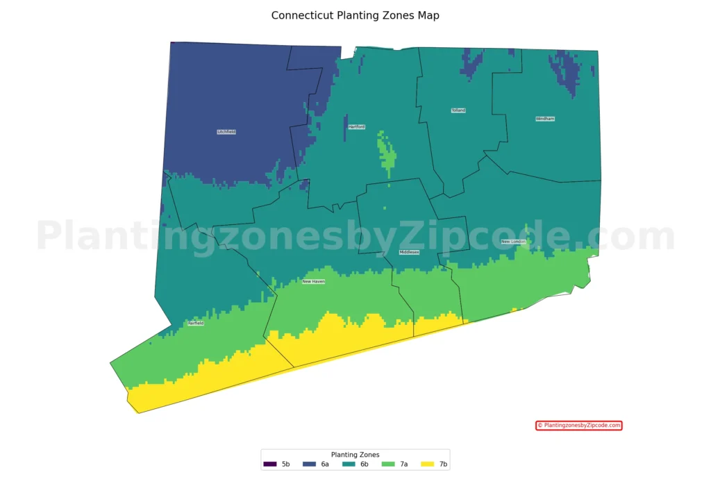
1. Zone 6a
Zone 6a, shown in dark blue color shade on our map above, covers the northwestern corner of Connecticut. With average annual minimum temperatures ranging from -10°F to -5°F (-23.3°C to -20.6°C), it is the coldest region in the state. It includes the Litchfield Hills and parts of the Berkshire Mountains foothills. Cities in this zone are Torrington, Winsted, and Norfolk.
2. Zone 6b
Zone 6b, the teal colored areas on the map, dominates most of Connecticut’s interior. Having average annual minimum temperatures between -5°F and 0°F (-20.6°C to -17.8°C), this zone covers a large area of the state. It includes the Connecticut River Valley and extends from the central regions to the eastern border. Major cities in this zone are Hartford, New Britain, and Middletown.
3. Zone 7a
Zone 7a, the light green colored areas on our map above, primarily covers the coastal regions and southern portions of Connecticut. This zone experiences average annual minimum temperatures from 0°F to 5°F (-17.8°C to -15°C). It includes the Long Island Sound shoreline and extends slightly inland. Cities in this zone include New Haven, Bridgeport, Fairfield, and Stamford.
4. Zone 7b
Zone 7b, the yellow colored areas on our map, is the warmest zone in Connecticut and covers only a narrow strip of area along the southernmost coastline. With average annual minimum temperatures between 5°F and 10°F (-15°C to -12.2°C), this zone benefits from the moderating effect of Long Island Sound. While it’s a small area, it includes parts of coastal cities like Norwalk and specific neighborhoods such as Old Greenwich and Riverside.
Planting Zones in Connecticut with Cities
USDA hardiness zones for Connecticut cities, towns and counties (Data: Latest USDA (2023) release)
| Planting Zones in Connecticut | Temp Range (°F) | Cities |
|---|---|---|
| 6b | -5 to 0 | Amston, Andover, Ansonia, Ashford, Avon, Ballouville, Baltic, Beacon Falls, Bethany, Bethel, Bloomfield, Bolton, Botsford, Bozrah, Bridgewater, Bristol, Broad Brook, Brookfield, Brooklyn, Canterbury, Central Village, Chaplin, Cheshire, Chester, Cobalt, Colchester, Columbia, Coventry, Cromwell, Danbury, Danielson, Dayville, Derby, Durham, East Berlin, East Glastonbury, East Granby, East Haddam, East Hampton, East Hartford, East Killingly, East Windsor, East Windsor Hill, Eastford, Easton, Ellington, Enfield, Farmington, Gaylordsville, Gilman, Glastonbury, Granby, Haddam, Hadlyme, Hamden, Hampton, Hanover, Hartford, Hawleyville, Hebron, Higganum, Jewett City, Kensington, Killingworth, Lebanon, Ledyard, Manchester, Mansfield Center, Mansfield Depot, Marion, Marlborough, Mashantucket, Meriden, Middle Haddam, Middlebury, Middlefield, Middletown, Milldale, Monroe, Moodus, Moosup, Naugatuck, New Britain, New Fairfield, New Milford, Newington, Newtown, North Franklin, North Haven, North Stonington, North Westchester, North Windham, Northford, Norwich, Oakdale, Oakville, Oneco, Oxford, Pequabuck, Plainfield, Plainville, Plantsville, Pomfret Center, Poquonock, Portland, Preston, Prospect, Putnam, Redding, Redding Center, Redding Ridge, Ridgefield, Rockfall, Rocky Hill, Rogers, Roxbury, Salem, Sandy Hook, Scotland, Seymour, Shelton, Sherman, Simsbury, Somers, Somersville, South Britain, South Glastonbury, South Willington, South Windham, South Windsor, South Woodstock, Southbury, Southington, Stafford Springs, Sterling, Stevenson, Storrs Mansfield, Suffield, Taftville, Tariffville, Terryville, Thompson, Tolland, Uncasville, Unionville, Vernon Rockville, Versailles, Voluntown, W Hartford, Wallingford, Waterbury, Watertown, Wauregan, Weatogue, West Simsbury, West Suffield, Wethersfield, Willimantic, Willington, Windham, Windsor, Windsor Locks, Wolcott, Woodbridge, Woodbury, Woodstock, Woodstock Valley, Yantic |
| 6a | -10 to -5 | Bantam, Bethlehem, Burlington, Canaan, Canton, Canton Center, Colebrook, Collinsville, Cornwall, Cornwall Bridge, East Canaan, East Hartland, East Woodstock, Fabyan, Falls Village, Goshen, Grosvenor Dale, Harwinton, Kent, Lakeside, Lakeville, Litchfield, Morris, New Hartford, New Preston Marble Dale, Norfolk, North Canton, North Granby, North Grosvenordale, Northfield, Pine Meadow, Pleasant Valley, Plymouth, Quinebaug, Riverton, Salisbury, Sharon, South Kent, Stafford, Staffordville, Taconic, Thomaston, Torrington, Washington, Washington Depot, West Cornwall, West Granby, West Hartland, Winchester Center, Winsted |
| 7a | 0 to 5 | Branford, Bridgeport, Centerbrook, Clinton, Cos Cob, Darien, Deep River, East Haven, East Lyme, Essex, Fairfield, Gales Ferry, Georgetown, Greens Farms, Greenwich, Groton, Guilford, Hamden, Ivoryton, Madison, Milford, Mystic, New Canaan, New Haven, New London, Niantic, North Branford, Norwalk, Old Lyme, Old Mystic, Old Saybrook, Orange, Pawcatuck, Quaker Hill, South Lyme, Southport, Stamford, Stonington, Stratford, Trumbull, Waterford, West Haven, West Mystic, Westbrook, Weston, Westport, Wethersfield, Wilton |
| 7b | 5 to 10 | Norwalk, Old Greenwich, Riverside |
How Connecticut’s geography influence its planting zones?
Connecticut’s geography factors like elevation, coastal influence and latitude directly influences its USDA growing zones:
- Elevation: Higher elevations in the northwest (Litchfield Hills) create cooler zones (6a), while lower elevations in the interior are mostly zone 6b.
- Coastal influence: Long Island Sound moderates temperatures along the southern coast, resulting in warmer zones (7a and 7b).
- Latitude: Generally, southern parts of the state are warmer than northern areas.