
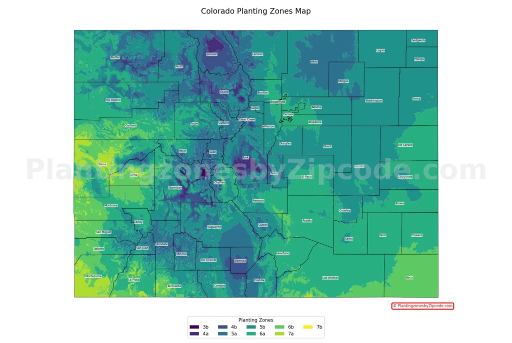
Colorado has 9 USDA planting zones, ranging from zone 3b to zone 7b. Average annual minimum temperatures range from -35°F to 10°F, according to the 2023 USDA Plant Hardiness Zone Map. The Rocky Mountains hold the coldest zones (3b through 5a). The Front Range covers zones 5b and 6a. The Western Slope reaches zones 6b and 7a. Denver is in zone 6a, and Grand Junction spans zones 6b and 7a.
Find your Colorado growing zone — also called the gardening zone, plant zone, garden zone, hardiness zone, or climate zone — using our ZIP code tool or the Colorado city map below. Browse every Colorado city, town, and county with its USDA zone in the Colorado cities, towns and counties directory.
Search Colorado Planting Zones by ZipCode
Planting Zones Colorado Map
Select your Colorado city in the selection box below. Use the top-right corner button in the map view to toggle map layers.
Planting Zones
Planting Zones
What are the 9 planting zones in Colorado?
1. Zone 3b
Zone 3b, shown in dark purple on our map, covers small pockets in the highest elevations of the Rocky Mountains. Average annual minimum temperatures range from -35°F to -30°F (-37.2°C to -34.4°C), the coldest in Colorado. This zone includes the state’s highest alpine areas.
2. Zone 4a
Zone 4a, shown in light purple on our map, covers high areas of the Rockies, including parts of the central Rockies. Average annual minimum temperatures range from -30°F to -25°F (-34.4°C to -31.7°C). Cities in zone 4a include Craig and Hartsel — among Colorado’s coldest inhabited areas.
3. Zone 4b
Zone 4b, shown in blue-purple on our map, covers high-elevation mountain regions and the San Luis Valley. Average annual minimum temperatures range from -25°F to -20°F (-31.7°C to -28.9°C). Cities in zone 4b include Steamboat Springs, Silverthorne, Walden, and Alamosa.
4. Zone 5a
Zone 5a, shown in teal on our map, covers Colorado’s mountain regions and parts of the high plains. Average annual minimum temperatures range from -20°F to -15°F (-28.9°C to -26.1°C). Cities in zone 5a include Aspen, Breckenridge, Vail, and Estes Park.
5. Zone 5b
Zone 5b, shown in light teal on our map, covers large parts of the Front Range and mountain valleys. Average annual minimum temperatures range from -15°F to -10°F (-26.1°C to -23.3°C). Cities in zone 5b include Fort Collins, Castle Rock, Greeley, Loveland, and parts of Colorado Springs.
6. Zone 6a
Zone 6a, shown in dark green on our map, covers lower elevations of the Front Range and western valleys. Average annual minimum temperatures range from -10°F to -5°F (-23.3°C to -20.6°C). Cities in zone 6a include Denver, Aurora, Boulder, Longmont, Pueblo, and Durango.
7. Zone 6b
Zone 6b, shown in green on our map, covers the western and southwestern parts of the state, plus some Eastern Plains. Average annual minimum temperatures range from -5°F to 0°F (-20.6°C to -17.8°C). Cities in zone 6b include Grand Junction, Durango, Montrose, and Delta.
8. Zone 7a
Zone 7a, shown in light green on our map, covers lower elevations of the Western Slope. Average annual minimum temperatures range from 0°F to 5°F (-17.8°C to -15°C), among Colorado’s mildest winter climates. Cities in zone 7a include Fruita, Cortez, Palisade, and parts of Grand Junction.
9. Zone 7b
Zone 7b, shown in yellow on our map, is the warmest zone in Colorado. Average annual minimum temperatures range from 5°F to 10°F (-15°C to -12.2°C). This zone exists in small pockets at the lowest elevations of the Western Slope, including microclimates near Grand Junction.
Colorado Planting Zones by Region
What planting zone is Denver?
Denver is in USDA zone 6a, with average annual minimum temperatures from -10°F to -5°F. Denver-area cities in the same zone include Aurora, Littleton, Englewood, Westminster, and Wheat Ridge.
What planting zone is Colorado Springs?
Colorado Springs sits primarily in USDA zone 6a, with average annual minimum temperatures from -10°F to -5°F. Higher-elevation parts of the city fall in zone 5b due to proximity to the Rockies.
What planting zone is northern Colorado?
Northern Colorado falls in USDA zones 5a through 6a, covering the northern Front Range and nearby mountains. Average annual minimum temperatures range from -20°F to -5°F. Cities include Fort Collins, Boulder, Greeley, Estes Park, and Loveland.
What planting zone is southern Colorado?
Southern Colorado falls in USDA zones 4b through 6b, spanning the San Luis Valley, the southern Rockies, and the Eastern Plains. Average annual minimum temperatures range from -25°F to 0°F. Cities include Pueblo, Durango, Alamosa, Trinidad, and Walsenburg.
What planting zone is the Western Slope?
The Western Slope falls in USDA zones 5b through 7a, reaching Colorado’s mildest winter temperatures (from -15°F to 5°F). Cities include Grand Junction, Fruita, Montrose, Delta, and Durango.
Planting Zones in Colorado with Cities
Find the USDA hardiness zone for every Colorado city, town, and county in the table below. Data Source: 2023 USDA Plant Hardiness Zone Map.
| Planting Zones in Colorado | Temp Range (°F) | Cities |
|---|---|---|
| 6a | -10 to -5 | Aguilar, Arapahoe, Arvada, Aurora, Avon, Avondale, Basalt, Bayfield, Bennett, Bethune, Beulah, Boncarbo, Boone, Boulder, Branson, Brighton, Broomfield, Burlington, Canon City, Carbondale, Cheraw, Cheyenne Wells, Coal Creek, Collbran, Colorado City, Colorado Springs, Commerce City, Crawford, Denver, Dinosaur, Dolores, Dupont, Durango, Eads, Eldorado Springs, Englewood, Florence, Fort Lyon, Fountain, Fowler, Gardner, Glenwood Springs, Golden, Granada, Hartman, Hasty, Hesperus, Hoehne, Holly, Hygiene, Idalia, Ignacio, Kim, La Junta, La Veta, Lafayette, Lamar, Las Animas, Littleton, Longmont, Louisville, Mancos, Manzanola, Marvel, Maybell, Mc Clave, Model, Montrose, New Castle, Norwood, Nucla, Olney Springs, Parachute, Penrose, Poncha Springs, Pueblo, Rangely, Ridgway, Rifle, Rockvale, Rocky Ford, Rye, Sheridan Lake, Silt, Snowmass, Somerset, Stratton, Swink, Trinchera, Trinidad, Vona, Walsenburg, Watkins, Westminster, Weston, Wetmore, Wheat Ridge, Whitewater, Wild Horse, Wiley, Wolcott, Yoder |
| 5b | -15 to -10 | Agate, Akron, Allenspark, Amherst, Anton, Antonito, Arlington, Arriba, Atwood, Bailey, Bellvue, Berthoud, Black Hawk, Bond, Brighton, Brush, Buena Vista, Buffalo Creek, Burns, Byers, Calhan, Carr, Cascade, Castle Rock, Cedaredge, Central City, Chama, Chromo, Cimarron, Coaldale, Colorado Springs, Conifer, Cope, Cotopaxi, Cripple Creek, Crook, Crowley, Dacono, Deer Trail, Del Norte, Dinosaur, Divide, Drake, Dumont, Eagle, Eckley, Edwards, Elbert, Elizabeth, Erie, Estes Park, Evans, Evergreen, Fairplay, Firestone, Flagler, Fleming, Fort Collins, Fort Garland, Fort Lupton, Fort Morgan, Franktown, Fraser, Frederick, Genoa, Glen Haven, Golden, Grant, Greeley, Green Mountain Falls, Guffey, Gunnison, Gypsum, Hamilton, Haswell, Haxtun, Henderson, Hillrose, Hillside, Holyoke, Hot Sulphur Springs, Howard, Hudson, Hugo, Idaho Springs, Idledale, Iliff, Indian Hills, Jamestown, Joes, Johnstown, Julesburg, Karval, Keenesburg, Kiowa, Kirk, Kit Carson, Kittredge, La Jara, Lake George, Laporte, Larkspur, Limon, Lindon, Littleton, Livermore, Longmont, Louviers, Loveland, Lyons, Manitou Springs, Masonville, Matheson, Mc Coy, Mead, Meeker, Merino, Milliken, Moffat, Molina, Monarch, Monument, Morrison, Nathrop, Nederland, Ophir, Ordway, Otis, Ouray, Ovid, Padroni, Pagosa Springs, Palmer Lake, Paoli, Parker, Peetz, Peyton, Pierce, Pine, Pinecliffe, Placerville, Platteville, Powderhorn, Pueblo, Ramah, Rico, Roggen, Rollinsville, Rush, Saguache, Salida, San Luis, Sargents, Sedalia, Sedgwick, Seibert, Severance, Shawnee, Simla, Slater, Snowmass Village, Snyder, South Fork, Steamboat Springs, Sterling, Stoneham, Strasburg, Sugar City, Tabernash, Telluride, Timnath, U S A F Academy, Vail, Vernon, Victor, Villa Grove, Ward, Wellington, Westcliffe, Windsor, Woodland Park, Woodrow, Woody Creek, Wray, Yuma |
| 5a | -20 to -15 | Alma, Almont, Aspen, Ault, Blanca, Breckenridge, Briggsdale, Capulin, Center, Clark, Climax, Como, Conejos, Craig, Creede, Crested Butte, Crestone, Dillon, Eaton, Empire, Estes Park, Florissant, Frisco, Galeton, Georgetown, Gilcrest, Gill, Granby, Grand Lake, Granite, Greeley, Grover, Hayden, Hereford, Hooper, Jaroso, Jefferson, Kersey, Kremmling, La Salle, Lake City, Leadville, Manassa, Meredith, Minturn, Monte Vista, Mosca, New Raymer, Nunn, Oak Creek, Ohio City, Orchard, Parshall, Phippsburg, Pitkin, Red Cliff, Red Feather Lakes, Romeo, Sanford, Silver Plume, Silverthorne, Silverton, Toponas, Twin Lakes, Vail, Weldona, Wiggins, Winter Park, Woodland Park, Yampa |
| 4b | -25 to -20 | Alamosa, Coalmont, Cowdrey, Homelake, Parlin, Rand, Silverthorne, Steamboat Springs, Walden |
| 4a | -30 to -25 | Craig, Hartsel |
| 6b | -5 to 0 | Arboles, Austin, Battlement Mesa, Bedrock, Cahone, Campo, Cory, De Beque, Delta, Dove Creek, Durango, Eckert, Egnar, Gateway, Glade Park, Grand Junction, Hotchkiss, Lazear, Lewis, Loma, Mesa, Montrose, Naturita, Olathe, Paonia, Paradox, Pleasant View, Pritchett, Redvale, Springfield, Two Buttes, Vilas, Walsh, Yellow Jacket |
| 7a | 0 to 5 | Clifton, Cortez, Fruita, Grand Junction, Mack, Mesa Verde National Park, Palisade, Towaoc |
What scientific data created Colorado’s planting zones?
The 2023 USDA Plant Hardiness Zone Map was developed by the PRISM Climate Group at Oregon State University. Their scientific algorithms interpolate temperature data, accounting for elevation, topography, and proximity to water. The result is a high-resolution map that captures Colorado’s climate from the Rocky Mountains to the plains and plateaus.