
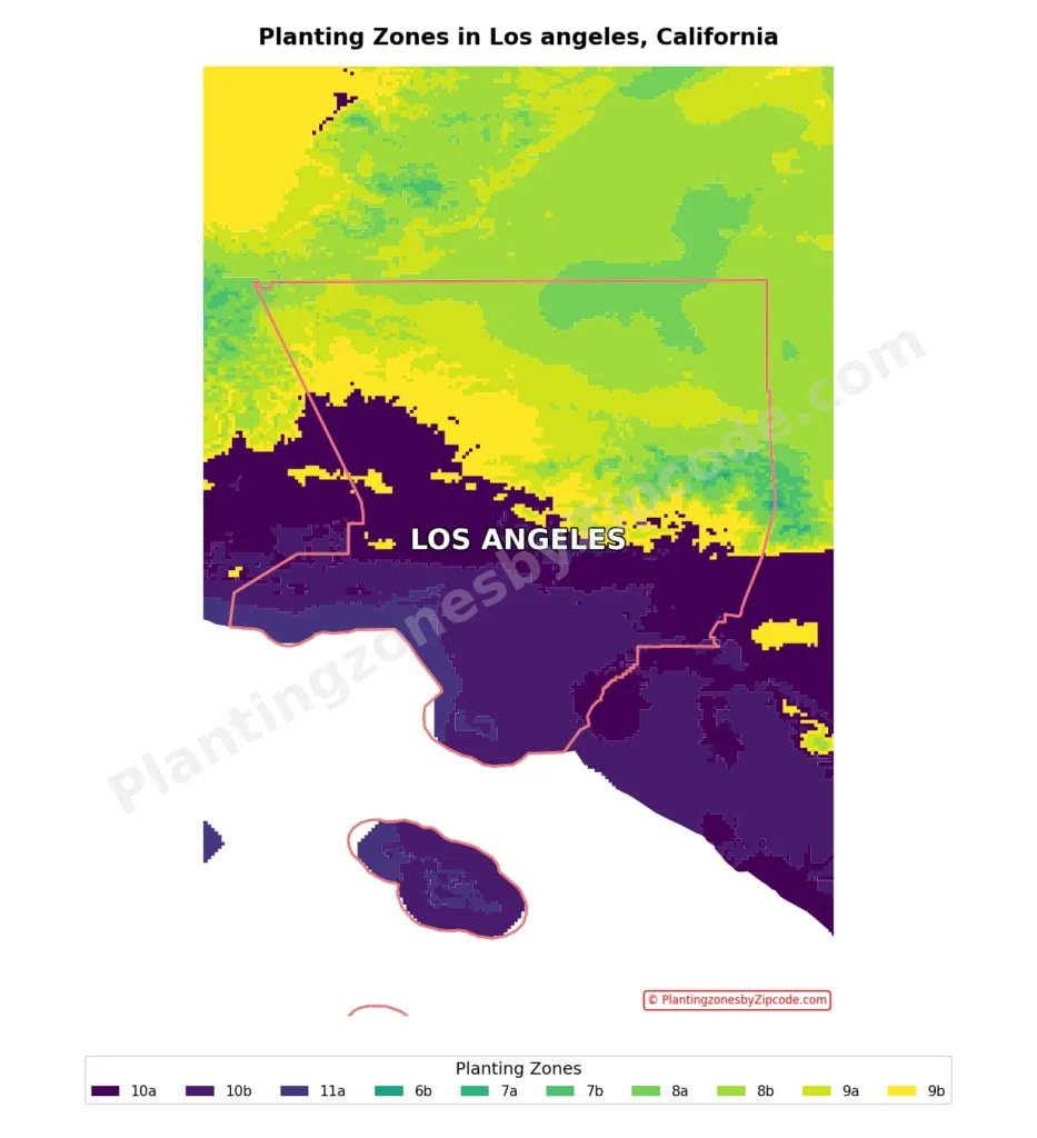
Los Angeles spans USDA zones 9a-11a in the city and 6b-11a countywide, as per latest USDA Map. The urban core areas primarily occupies zones 10a-10b due to its Mediterranean climate, with zone 9 areas in northern neighborhoods like Chatsworth.
You can pinpoint your Los Angeles, CA, USDA zone using our three tools given below, Zipcode to planting zone tool, Easy interactive map or by using planting zone table.
Los Angeles Planting Zones by ZipCode
Planting Zones Los Angeles Map
Select or type your Los Angeles location in the selection box below.
City Name
Los Angeles Area Planting Zone
Planting Zones
Planting Zones
Los Angeles Planting Zones Table
| Location | Planting Zone |
|---|---|
| Loading Los Angeles zones data… | |
No items found matching your search
Try a different search term or clear the search field.
What are the 5 planting zones in Los Angeles City, California?
The 5 planting zones in Los Angeles City, California are Zone 9a, Zone 9b, Zone 10a, Zone 10b, and Zone 11a. The 5 planting zones in Los Angeles City, California are listed below.
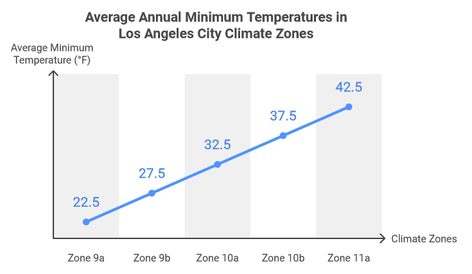
- Zone 9a (20°F–25°F / -6.7°C to -3.9°C): Northern elevated areas like San Gabriel Mountains foothills, ideal for native plants like California Poppy.
- Zone 9b (25°F–30°F / -3.9°C to -1.1°C): San Fernando Valley transition zone with urban-alluvial soils, suited for Mediterranean shrubs.
- Zone 10a (30°F–35°F / -1.1°C to 1.7°C): Mild Eagle Rock and Downtown LA areas, perfect for lavender and citrus trees.
- Zone 10b (35°F–40°F / 1.7°C to 4.4°C): Dominant coastal-central zone with Jacarandas and ocean-stabilized climates.
- Zone 11a (40°F–45°F / 4.4°C to 7.2°C): Rare Santa Monica Mountains microclimates favoring Agave and heat-tolerant grasses.
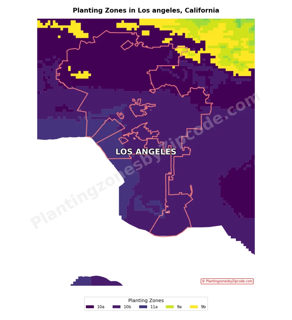
1. Zone 9a
This zone, represented by the light green areas on our map above, is found in the northernmost parts of Los Angeles. With average annual minimum temperatures ranging from 20°F to 25°F (-6.7°C to -3.9°C), it represents the coolest areas within the city limits.
While not prevalent in the main urban areas, this zone includes some of the elevated regions within the city, extending into the foothills of the San Gabriel Mountains. Native plants like California Poppy and Manzanita are well-adapted to these conditions.
2. Zone 9b
Shown in yellow color on our map above, Zone 9b forms a narrow band along the northern edge of Los Angeles. This zone experiences average annual minimum temperatures between 25°F to 30°F (-3.9°C to -1.1°C).
It serves as a transition area between the cooler northern regions and the more temperate central parts of the city, covering areas of the San Fernando Valley. The soils here include alluvial deposits in valley areas, mixed with urban soils in more developed regions.
3. Zone 10a
Zone 10a, shown in bright purple color on the map, covers a large area of northern Los Angeles. With average annual minimum temperatures ranging from 30°F to 35°F (-1.1°C to 1.7°C), this zone includes areas like Eagle Rock (90041), Highland Park (90042), Downtown Los Angeles (90050), and Glassell Park (90065).
It have some of the more elevated neighborhoods and represents a mild climate suitable for a wide range of plants, including drought-tolerant options like lavender and sage. The Mediterranean climate of Los Angeles, characterized by mild, dry summers and cool, wet winters, is particularly evident in this zone, which include parts of the San Gabriel Valley.
4. Zone 10b
The most prevalent zone in Los Angeles, 10b is shown in dark purple color on our map and covers the majority of the city. This zone experiences average annual minimum temperatures between 35°F to 40°F (1.7°C to 4.4°C).
It includes most of the central, western, and southern parts of Los Angeles, covering numerous zip codes such as Florence (90001), Watts (90002), South Central (90003), and many others. Key areas within this zone include downtown Los Angeles, Hollywood, and most of the coastal regions.
The coastal location of this zone contributes to its stable atmosphere and clear skies, influenced by the cool California Current offshore and the proximity to the Pacific Ocean. This zone is suitable for a variety of plants, including the iconic Jacaranda trees that have become a symbol of Los Angeles.
5. Zone 11a
While not prominently visible on the map, Zone 11a exists in small pockets or microclimates within Los Angeles, particularly in coastal areas or urban heat islands. This zone has average annual minimum temperatures between 40°F to 45°F (4.4°C to 7.2°C), representing the warmest areas in the city.
Its presence is limited and highly localized, in some areas near the Santa Monica Mountains or along the Los Angeles River. These areas experience the most pronounced effects of the high-pressure systems that frequently influence the region, especially during summer, promoting clear, sunny conditions. This zone is suitable for drought-tolerant plants like Agave and ornamental grasses such as Purple Fountain Grass.
What are the 10 planting zones in Los Angeles County, California?
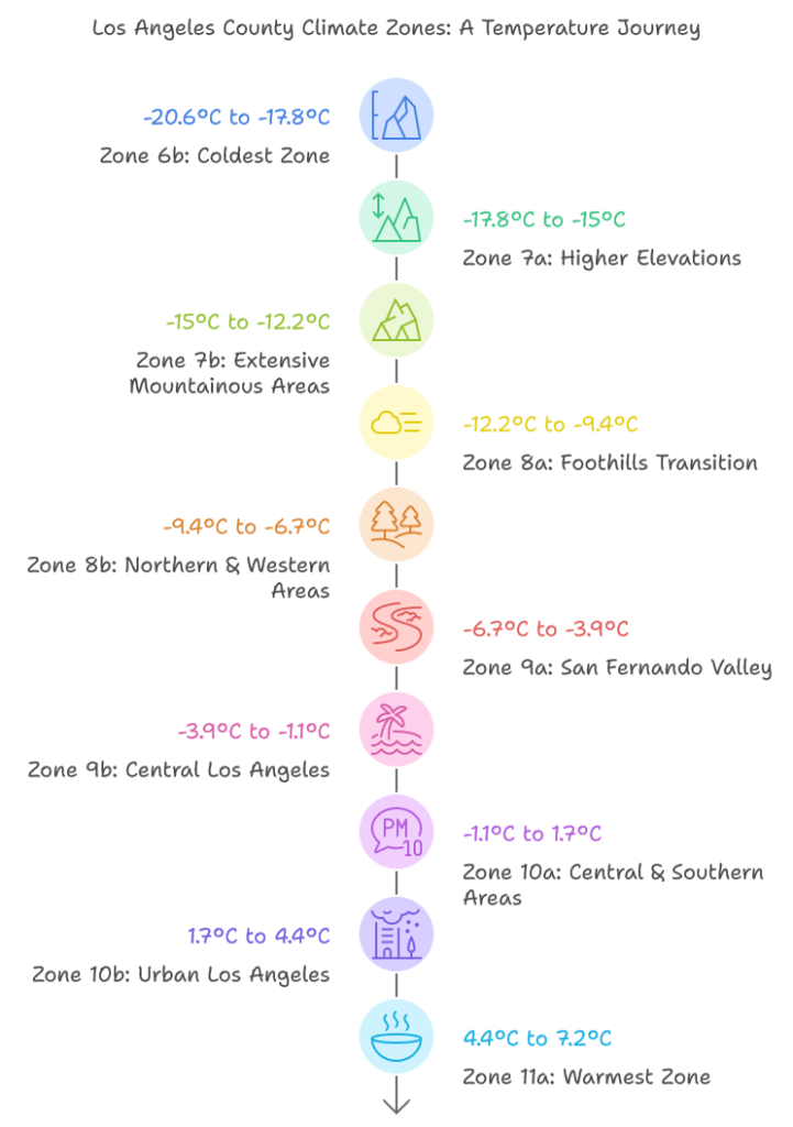
The 10 planting zones in Los Angeles County, California are Zone 6b, Zone 7a, Zone 7b, Zone 8a, Zone 8b, Zone 9a, Zone 9b, Zone 10a, Zone 10b, and Zone 11a. The 10 planting zones in Los Angeles County, California are listed below.
- Zone 6b: Zone 6b has average annual minimum temperatures of -5°F to 0°F (-20.6°C to -17.8°C), found in the San Gabriel Mountains’ highest elevations. This coldest zone supports hardy plants adapted to rocky, mineral-rich serpentine soils.
- Zone 7a: Zone 7a experiences temperatures between 0°F and 5°F (-17.8°C to -15°C), covering parts of the Angeles National Forest. Its fertile alluvial soils suit moisture-tolerant species like mountain shrubs.
- Zone 7b: Zone 7b ranges from 5°F to 10°F (-15°C to -12.2°C), spanning the Santa Monica Mountains and Angeles National Forest. Clay soils here retain moisture but require plants resistant to compaction.
- Zone 8a: Zone 8a has temperatures of 10°F to 15°F (-12.2°C to -9.4°C), located in foothills between mountains and urban areas. Loamy soils in this zone support drought-resistant perennials.
- Zone 8b: Zone 8b covers 15°F to 20°F (-9.4°C to -6.7°C) areas like the Santa Clarita Valley. Sandy soils here drain well but need nutrient-rich plants like succulents.
- Zone 9a: Zone 9a ranges from 20°F to 25°F (-6.7°C to -3.9°C), including the San Fernando and San Gabriel Valleys. With 284 annual sunny days, it suits lavender, sage, and citrus trees.
- Zone 9b: Zone 9b spans 25°F to 30°F (-3.9°C to -1.1°C), covering coastal areas and downtown Los Angeles. Urban soils here vary but work for ornamental grasses and palms.
- Zone 10a: Zone 10a experiences 30°F to 35°F (-1.1°C to 1.7°C), found in Pasadena and Altadena. Native plants like California poppy thrive in its well-draining soils.
- Zone 10b: Zone 10b covers 35°F to 40°F (1.7°C to 4.4°C) across most of metropolitan Los Angeles. High-pressure systems create ideal conditions for purple fountain grass and bougainvillea.
- Zone 11a: Zone 11a, the warmest at 40°F to 45°F (4.4°C to 7.2°C), includes Catalina Island and coastal regions. Mild winters here suit subtropical species like bird-of-paradise and plumeria.
1. Zone 6b
Zone 6b, represented by a small teal colored area on our map above, is the coldest zone in Los Angeles County. With average annual minimum temperatures ranging from -5°F to 0°F (-20.6°C to -17.8°C), this zone is found in the highest elevations of the San Gabriel Mountains.
This zone experiences harsh winters and is characterized by dense forests and rugged terrain. The serpentine soils found in some areas of this zone support unique plant communities adapted to high levels of heavy metals and low calcium-to-magnesium ratios.
2. Zone 7a
Shown in dark green color on the map, Zone 7a experiences average annual minimum temperatures between 0°F and 5°F (-17.8°C to -15°C). This zone is primarily found in the higher elevations of the Angeles National Forest and parts of the Santa Monica Mountains.
Though sparsely populated, it shapes the Mediterranean climate that Los Angeles County is known for. The alluvial soils in the valleys and floodplains of this zone are fertile and well-draining, making them suitable for a variety of plant species.
3. Zone 7b
Zone 7b, shown in a lighter green color on our map above, covers more extensive areas of the mountainous regions in Los Angeles County. With temperatures ranging from 5°F to 10°F (-15°C to -12.2°C), this zone encompasses larger portions of the Angeles National Forest and extends into parts of the Santa Monica Mountains.
The terrain here is characterized by dense forests and steep slopes and the clay soils present in this zone have high water-holding capacity but can be prone to compaction.
4. Zone 8a
Represented by a pale green color shade on the map, Zone 8a has average annual minimum temperatures between 10°F and 15°F (-12.2°C to -9.4°C). This zone is found in the foothills of the San Gabriel Mountains and parts of the Santa Monica Mountains, creating a transition between the mountainous and urban areas of the county. The loamy soils found in some agricultural areas of this zone are ideal for plant growth.
5. Zone 8b
Zone 8b, shown in a yellowish-green color on our map, covers large area of the northern and western parts of Los Angeles County. With temperatures ranging from 15°F to 20°F (-9.4°C to -6.7°C), this zone includes areas like the Santa Clarita Valley and parts of the San Fernando Valley.
The sandy soils found in this zone are well-draining but may have low nutrient content.
6. Zone 9a
The light yellow colored areas on our map, Zone 9a experiences average annual minimum temperatures between 20°F and 25°F (-6.7°C to -3.9°C). This zone covers large areas of the San Fernando Valley and extends into parts of the San Gabriel Valley, including cities like Burbank and Glendale.
The Mediterranean climate in this zone contributes to the region’s approximately 284 sunny days per year, making it suitable for a wide range of plant species, including drought-tolerant plants like lavender and sage.
7. Zone 9b
Zone 9b, shown in a brighter yellow color on the map, is widespread across the central parts of Los Angeles County. With temperatures ranging from 25°F to 30°F (-3.9°C to -1.1°C), this zone includes much of the Los Angeles Basin and coastal areas.
Cities like Santa Monica and parts of downtown Los Angeles fall within this zone, benefiting from the coastal location that influences weather patterns and creates stable atmospheric conditions. The urban soils in this zone are often highly modified and can vary significantly in composition and quality.
8. Zone 10a
Represented by the darkest purple color on the map, Zone 10a covers a large area of central and southern Los Angeles County. With average annual minimum temperatures between 30°F and 35°F (-1.1°C to 1.7°C), this zone includes cities like Pasadena, Altadena, and parts of East Los Angeles. The soil found in this zone supports native plants like California poppy and ceanothus.
9. Zone 10b
Zone 10b, shown in a slightly lighter purple color on our map, is the most prevalent zone in the urban areas of Los Angeles County. With temperatures ranging from 35°F to 40°F (1.7°C to 4.4°C), this zone covers the majority of the Los Angeles metropolitan area.
It includes most of the city of Los Angeles, as well as surrounding areas like Beverly Hills, Culver City, and Long Beach. The high-pressure systems that frequently influence this zone contribute to the clear, sunny conditions experienced throughout much of the year, making it suitable for ornamental grasses like purple fountain grass and blue fescue.
10. Zone 11a
The warmest zone in Los Angeles County, Zone 11a, is represented by small areas of dark blue color on our map above. With average annual minimum temperatures between 40°F and 45°F (4.4°C to 7.2°C), this zone is found in the most coastal areas and on Catalina Island.
This zone have the mildest winter temperatures in the county, suitable for subtropical plants which can benefit from the Mediterranean climate here that provides abundant sunshine, especially during the summer months. The saline soils present in some coastal areas of this zone have high salt content due to marine influence or poor drainage.