
Alaska has 16 USDA planting zones, ranging from Zone 1a to Zone 8b, per the 2023 USDA Plant Hardiness Zone Map. These growing zones — also called hardiness zones, gardening zones, or plant zones — span average annual minimum temperatures from below -60°F in the far north to 20°F along the southern Panhandle.
Zone 1a, the coldest, covers the northernmost parts including the North Slope Borough, while zone 8b, the warmest, is found in the southernmost tip of the Alaska Panhandle.
Zones change gradually southward, with interior Alaska colder than coastal areas at similar latitudes. Major cities — including Fairbanks (Zone 2a), Anchorage (Zone 4a), and Juneau (Zone 7a) — fall into different zones, reflecting Alaska’s climatic diversity.
Find your Alaska planting zone on the interactive map below — select or type your city, town, or place. The Alaska cities, towns, and boroughs list shows hardiness zones for every AK location.
Planting Zones Alaska Map
Select or type your Alaska city or town in the selection box below. Use the top-right corner button in the map view to toggle map layers.
Planting Zones
Planting Zones
What are the 16 planting zones in Alaska?
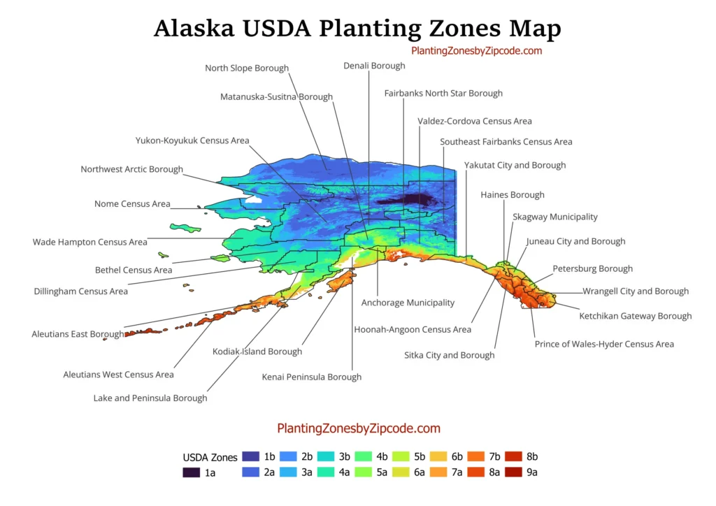
1. Zone 1a
Zone 1a, shown in darkest purple on our map, covers the northernmost parts of Alaska, including the North Slope Borough. With average annual minimum temperatures below -60°F (-51.1°C), this zone has the harshest growing conditions in the state. Cities in Zone 1a include Barrow and Nome.
2. Zone 1b
Zone 1b, shown in dark blue on our map, covers areas just south of Zone 1a, including parts of the Northwest Arctic Borough. This zone has average annual minimum temperatures between -55°F to -50°F (-48.3°C to -45.6°C). Kotzebue is a notable city in Zone 1b.
3. Zone 2a
Zone 2a, shown in deep blue on our map, covers a large area of interior Alaska. With average annual minimum temperatures ranging from -50°F to -45°F (-45.6°C to -42.8°C), it includes the Fairbanks North Star Borough. Fairbanks is a key city in Zone 2a.
4. Zone 2b
Zone 2b, shown in light blue on our map, extends across central Alaska. This zone experiences average annual minimum temperatures between -45°F to -40°F (-42.8°C to -40°C). Eagle is a notable town in Zone 2b.
5. Zone 3a
Zone 3a, shown in pale blue on our map, covers parts of western and south-central Alaska. With average annual minimum temperatures from -40°F to -35°F (-40°C to -37.2°C), it includes the Yukon-Koyukuk Census Area. McGrath is a notable settlement in Zone 3a.
6. Zone 3b
Zone 3b, shown in greenish-blue on our map, covers parts of south-central Alaska, including portions of the Matanuska-Susitna Borough. This zone has average annual minimum temperatures between -35°F to -30°F (-37.2°C to -34.4°C). Palmer lies within Zone 3b.
7. Zone 4a
Zone 4a, shown in light green on our map, covers areas around Cook Inlet and parts of the Kenai Peninsula, with average annual minimum temperatures from -30°F to -25°F (-34.4°C to -31.7°C). Anchorage, Alaska’s largest city, sits in Zone 4a along with the rest of the Anchorage Municipality.
8. Zone 4b
Zone 4b, shown in brighter green on our map, extends across the Matanuska-Susitna Valley and southern coastal areas. This zone experiences average annual minimum temperatures between -25°F to -20°F (-31.7°C to -28.9°C). The Mat-Su Valley is a key region in Zone 4b.
9. Zone 5a
Zone 5a, shown in yellowish-green on our map, covers parts of the southern coast and some islands. With average annual minimum temperatures from -20°F to -15°F (-28.9°C to -26.1°C), it includes areas like the Kenai Peninsula Borough and the city of Seward.
10. Zone 5b
Zone 5b, shown in greenish-yellow on our map, covers coastal areas in south-central Alaska. This zone experiences average annual minimum temperatures between -15°F to -10°F (-26.1°C to -23.3°C). Homer is a key city in Zone 5b.
11. Zone 6a
Zone 6a, shown in dull yellow on our map, covers parts of the southern coast and some islands in the Gulf of Alaska. With average annual minimum temperatures from -10°F to -5°F (-23.3°C to -20.6°C), it includes Prince William Sound and the city of Valdez.
12. Zone 6b
Zone 6b, shown in yellowish-orange on our map, extends across parts of south-central Alaska and some coastal areas. This zone has average annual minimum temperatures between -5°F to 0°F (-20.6°C to -17.8°C). Glennallen is a notable town in Zone 6b.
13. Zone 7a
Zone 7a, shown in reddish-orange on our map, covers parts of southeastern Alaska, including the Inside Passage. With average annual minimum temperatures from 0°F to 5°F (-17.8°C to -15°C), it includes areas of the Alaska Panhandle. Juneau, the state capital, sits in Zone 7a.
14. Zone 7b
Zone 7b, shown in brighter red on our map, covers coastal areas of southeastern Alaska. This zone experiences average annual minimum temperatures between 5°F to 10°F (-15°C to -12.2°C). Sitka is a key city in Zone 7b.
15. Zone 8a
Zone 8a, shown in deep red on our map, covers the southernmost coastal areas of southeastern Alaska. With average annual minimum temperatures from 10°F to 15°F (-12.2°C to -9.4°C), it includes parts of the Alexander Archipelago. Ketchikan is an important city in Zone 8a.
16. Zone 8b
Zone 8b, the warmest in Alaska, appears in darkest red on our map. It covers the extreme southern tip of the Alaska Panhandle. This zone experiences average annual minimum temperatures between 15°F to 20°F (-9.4°C to -6.7°C). Petersburg is a notable town in Zone 8b.
Does Alaska have all the USDA zones?
No, Alaska does not have all the USDA plant hardiness zones. Based on the 2023 USDA Plant Hardiness Zone Map, Alaska has zones 1a to 8b. The state’s size and geography span a wide range of climate conditions, but it does not include the warmest USDA zones (9-13) found in more southern parts of the United States.